The world wars: world in 1914 and 1945
Between 1914 and 1945, 77 states appear on the map of world and 42 disappear. Among those that vanish: Russian Empire, Manchu Empire, French West Africa. New on the map: USSR, Antarctica, China. Rhodesia loses the most territory.
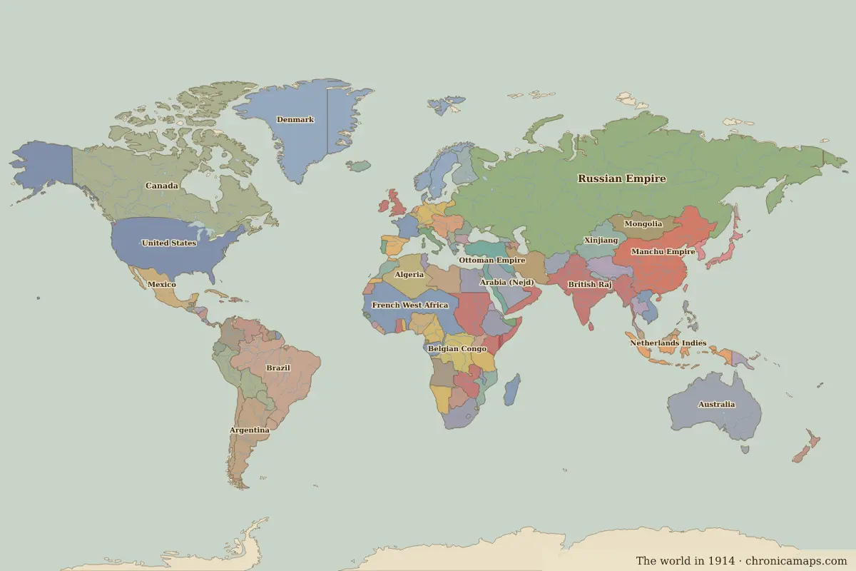
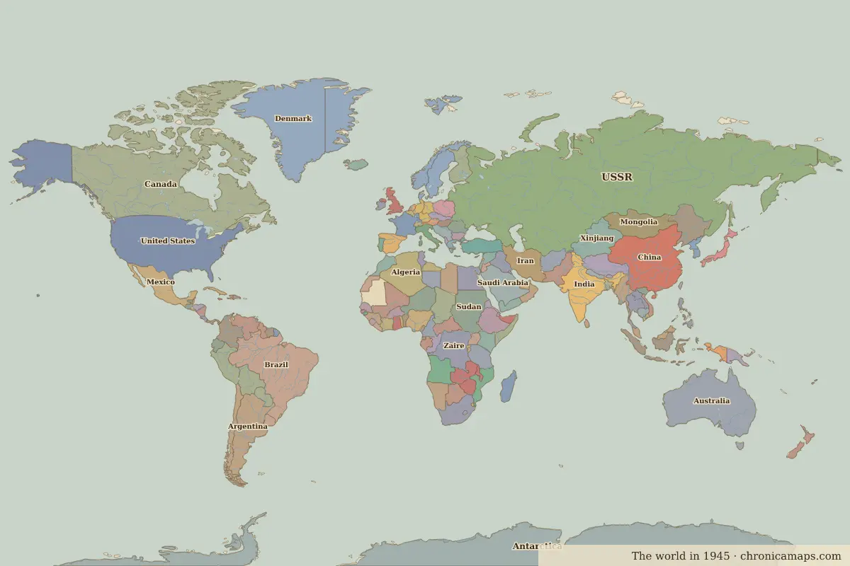
Open 1945 in the interactive map
States that disappeared
| State | Area in 1914 |
|---|---|
| Russian Empire | 21.46 million km² |
| Manchu Empire | 6.57 million km² |
| French West Africa | 6.39 million km² |
| British Raj | 4.81 million km² |
| Anglo-Egyptian Sudan | 2.59 million km² |
| Belgian Congo | 2.35 million km² |
| Ottoman Empire | 1.80 million km² |
| Arabia (Nejd) | 1.77 million km² |
| Netherlands Indies | 1.70 million km² |
| Persia | 1.61 million km² |
| Libya | 1.38 million km² |
| Angola | 1.24 million km² |
New states on the map
| State | Area in 1945 |
|---|---|
| USSR | 21.76 million km² |
| Antarctica | 12.19 million km² |
| China | 5.45 million km² |
| India | 3.20 million km² |
| Sudan | 2.51 million km² |
| Zaire | 2.35 million km² |
| Saudi Arabia | 1.92 million km² |
| Iran | 1.61 million km² |
| Indonesia | 1.32 million km² |
| Chad | 1.27 million km² |
| Mali | 1.25 million km² |
| Angola (Portugal) | 1.24 million km² |
States that grew or shrank
| State | Change in area |
|---|---|
| Rhodesia | −760,000 km² |
| British Somaliland | −270,000 km² |
| Chile | +120,000 km² |
| Romania | +40,000 km² |
| Uganda | −40,000 km² |
| Gold Coast | +40,000 km² |
| Morocco | +40,000 km² |
| Bulgaria | −30,000 km² |
What happened in between
| Year | Event | Where |
|---|---|---|
| 1915 | Gallipoli campaign | Gallipoli Campaign |
| 1916 | Verdun and the Somme | Battle of Verdun |
| 1917 | Russian October Revolution | St Petersburg |
| 1918 | WWI ends; empires collapse | |
| 1919 | Treaty of Versailles | Versailles |
| 1922 | Soviet Union founded | Moscow |
| 1923 | Republic of Turkey proclaimed | Ankara |
| 1929 | The Wall Street Crash | New York |
| 1935 | The Zunyi Conference | Zunyi Conference |
| 1937 | Marco Polo Bridge Incident: full-scale war between China and Japan | Beijing |
| 1938 | Anschluss; Munich Agreement | |
| 1939 | Germany invades Poland; WWII begins | Warsaw |
| 1941 | The attack on Pearl Harbor | Battle of Pearl Harbor |
| 1942 | Battle of Stalingrad | Battle of Stalingrad |
| 1942 | Fall of Singapore | Singapore |
| 1942 | Battle of Midway | Battle of Midway |
Battles of the period
- Gallipoli Campaign · 1915
- Battle of Verdun · 1916
- Battle of the Somme · 1916
- Versailles · 1919
- Zunyi Conference · 1935
- Battle of Pearl Harbor · 1941
- Battle of Stalingrad · 1942
- Battle of Guadalcanal · 1942
- Battle of Midway · 1942
- Battle of Kokoda Track · 1942
- Battle of Kursk · 1943
- Normandy Landings · 1944
- Battle of Kohima · 1944
- Yalta · 1945
- Battle of Iwo Jima · 1945
- Battle of Okinawa · 1945
People of the period
| Lived | Person | |
|---|---|---|
| 1856 – 1939 | Sigmund Freud | Founder of psychoanalysis |
| 1866 – 1925 | Sun Yat-sen | Founder of the Republic of China |
| 1869 – 1948 | Mahatma Gandhi | Leader of Indian independence |
| 1874 – 1965 | Winston Churchill | British prime minister |
| 1878 – 1953 | Joseph Stalin | Soviet leader |
| 1881 – 1938 | Mustafa Kemal Atatürk | Founder of the Republic of Turkey |
| 1889 – 1964 | Jawaharlal Nehru | First prime minister of India |
| 1890 – 1969 | Ho Chi Minh | Vietnamese revolutionary leader |
| c. 1897 – 1978 | Jomo Kenyatta | First president of Kenya |
| 1918 – 1970 | Gamal Abdel Nasser | President of Egypt |
Questions
How did the map of world change between 1914 and 1945?
Between 1914 and 1945, 77 states appear on the map of world and 42 disappear. Among those that vanish: Russian Empire, Manchu Empire, French West Africa. New on the map: USSR, Antarctica, China. Rhodesia loses the most territory.
Which states disappeared from the map of world between 1914 and 1945?
Russian Empire, Manchu Empire, French West Africa, British Raj, Anglo-Egyptian Sudan, Belgian Congo, Ottoman Empire, Arabia (Nejd), Netherlands Indies, Persia.
Which new states appeared between 1914 and 1945?
USSR, Antarctica, China, India, Sudan, Zaire, Saudi Arabia, Iran, Indonesia, Chad.
Borders are drawn from the nearest available maps and are approximate.
Last updated 10 November 2026. Sources: border data from historical-basemaps, land and rivers from Natural Earth; texts written for Chronica Maps from standard reference works. How we make the maps.