The age of empires: world in 1800 and 1914
Between 1800 and 1914, 93 states appear on the map of world and 94 disappear. Among those that vanish: Qing Empire, Viceroyalty of Brazil, Rupert's Land. New on the map: United States, Canada, Brazil. Russian Empire gains the most territory.
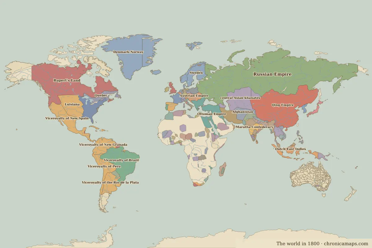
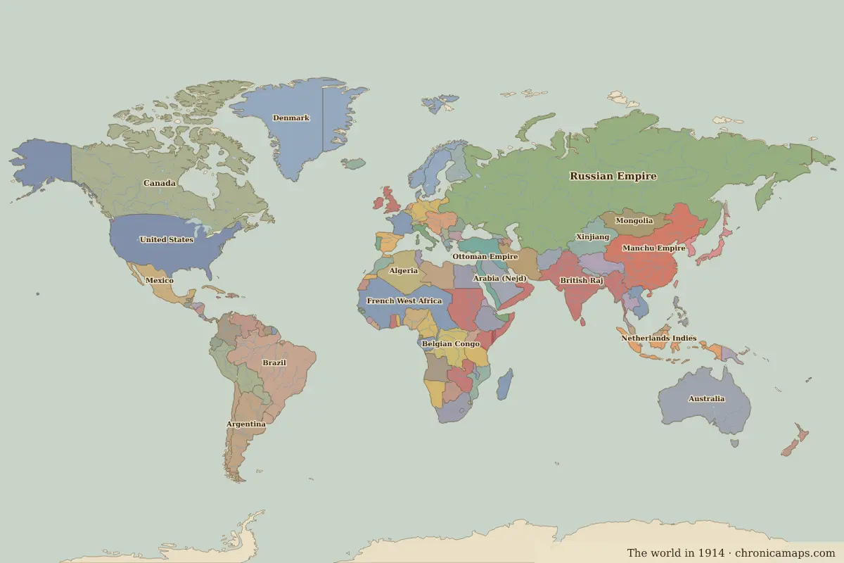
Open 1914 in the interactive map
States that disappeared
| State | Area in 1800 |
|---|---|
| Qing Empire | 12.21 million km² |
| Viceroyalty of Brazil | 8.10 million km² |
| Rupert's Land | 7.85 million km² |
| Viceroyalty of New Spain | 4.09 million km² |
| central Asian khanates | 3.47 million km² |
| Luisiana | 3.14 million km² |
| Viceroyalty of New Granada | 3.09 million km² |
| Viceroyalty of Peru | 2.80 million km² |
| Denmark-Norway | 2.56 million km² |
| Viceroyalty of the Río de la Plata | 2.36 million km² |
| United States of America | 2.30 million km² |
| Dutch East Indies | 1.70 million km² |
New states on the map
| State | Area in 1914 |
|---|---|
| United States | 9.38 million km² |
| Canada | 9.37 million km² |
| Brazil | 8.42 million km² |
| Australia | 7.66 million km² |
| Manchu Empire | 6.57 million km² |
| French West Africa | 6.39 million km² |
| British Raj | 4.81 million km² |
| Argentina | 2.78 million km² |
| Anglo-Egyptian Sudan | 2.59 million km² |
| Algeria | 2.46 million km² |
| Belgian Congo | 2.35 million km² |
| Denmark | 2.13 million km² |
States that grew or shrank
| State | Change in area |
|---|---|
| Russian Empire | +5.12 million km² |
| Ottoman Empire | −1.29 million km² |
| Afghanistan | −660,000 km² |
| Rattanakosin Kingdom | −330,000 km² |
| Sweden | −320,000 km² |
| Spain | −150,000 km² |
| Morocco | −120,000 km² |
| Nepal | −60,000 km² |
| Paraguay | +60,000 km² |
| Portuguese Guinea | +20,000 km² |
What happened in between
| Year | Event | Where |
|---|---|---|
| 1804 | Haiti becomes independent | |
| 1805 | Austerlitz and Trafalgar | Battle of Austerlitz |
| 1806 | Holy Roman Empire dissolved | Vienna |
| 1808 | The Portuguese court moves to Rio | Rio de Janeiro |
| 1809 | Finland passes to Russia | Turku |
| 1810 | The Mexican War of Independence begins | |
| 1812 | Napoleon invades Russia | Battle of Borodino |
| 1815 | Waterloo; Congress of Vienna | Battle of Waterloo |
| 1819 | Battle of Boyacá | Battle of Boyacá |
| 1822 | Brazil becomes independent | Rio de Janeiro |
| 1824 | Battle of Ayacucho | Battle of Ayacucho |
| 1827 | Battle of Navarino | Battle of Navarino |
| 1830 | Belgian independence | Brussels |
| 1836 | Battle of the Alamo | Battle of The Alamo |
| 1838 | Battle of Blood River | Battle of Blood River |
| 1840 | Treaty of Waitangi | Waitangi |
Battles of the period
- Battle of Austerlitz · 1805
- Battle of Trafalgar · 1805
- Battle of Borodino · 1812
- Battle of Leipzig · 1813
- Battle of Waterloo · 1815
- Battle of Boyacá · 1819
- Battle of Ayacucho · 1824
- Battle of Navarino · 1827
- Battle of The Alamo · 1836
- Battle of Blood River · 1838
- Waitangi · 1840
- Battle of Gettysburg · 1863
- Suez Canal · 1869
- Battle of Sedan · 1870
- Battle of Isandlwana · 1879
- Battle of Weihaiwei · 1895
People of the period
| Lived | Person | |
|---|---|---|
| 1724 – 1804 | Immanuel Kant | Philosopher |
| 1769 – 1849 | Muhammad Ali Pasha | Ruler of Egypt |
| 1781 – 1826 | Stamford Raffles | British colonial official |
| 1807 – 1882 | Giuseppe Garibaldi | Leader of Italian unification |
| 1818 – 1883 | Karl Marx | Philosopher and economist |
| 1835 – 1908 | Empress Dowager Cixi | De facto ruler of Qing China |
| 1853 – 1895 | José Martí | Cuban poet and independence leader |
| 1867 – 1934 | Marie Curie | Physicist and chemist |
| 1878 – 1953 | Joseph Stalin | Soviet leader |
| 1890 – 1970 | Charles de Gaulle | President of France |
Questions
How did the map of world change between 1800 and 1914?
Between 1800 and 1914, 93 states appear on the map of world and 94 disappear. Among those that vanish: Qing Empire, Viceroyalty of Brazil, Rupert's Land. New on the map: United States, Canada, Brazil. Russian Empire gains the most territory.
Which states disappeared from the map of world between 1800 and 1914?
Qing Empire, Viceroyalty of Brazil, Rupert's Land, Viceroyalty of New Spain, central Asian khanates, Luisiana, Viceroyalty of New Granada, Viceroyalty of Peru, Denmark-Norway, Viceroyalty of the Río de la Plata.
Which new states appeared between 1800 and 1914?
United States, Canada, Brazil, Australia, Manchu Empire, French West Africa, British Raj, Argentina, Anglo-Egyptian Sudan, Algeria.
Borders are drawn from the nearest available maps and are approximate.
Last updated 10 November 2026. Sources: border data from historical-basemaps, land and rivers from Natural Earth; texts written for Chronica Maps from standard reference works. How we make the maps.