Unification of Italy and Germany: Europe in 1815 and 1880
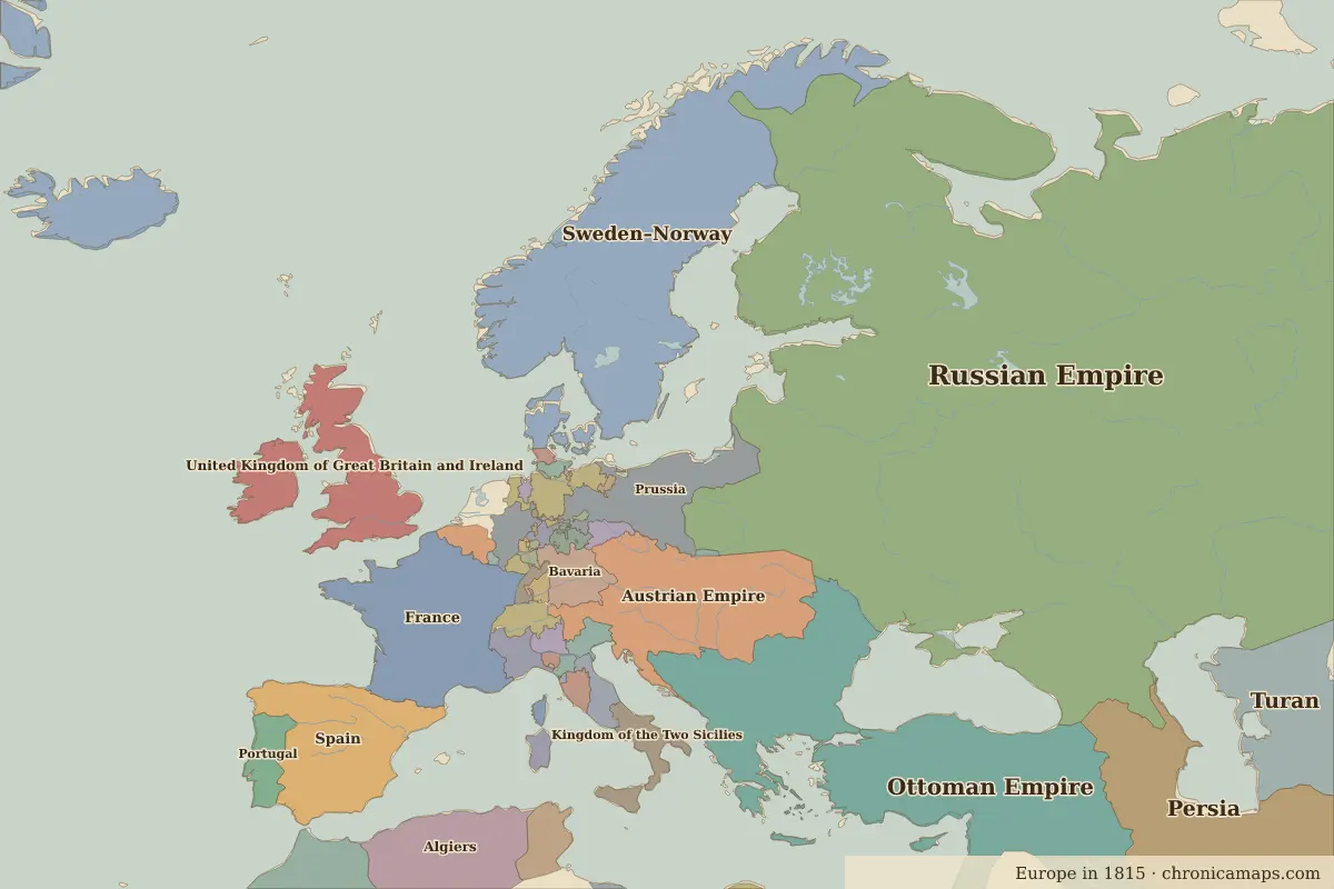
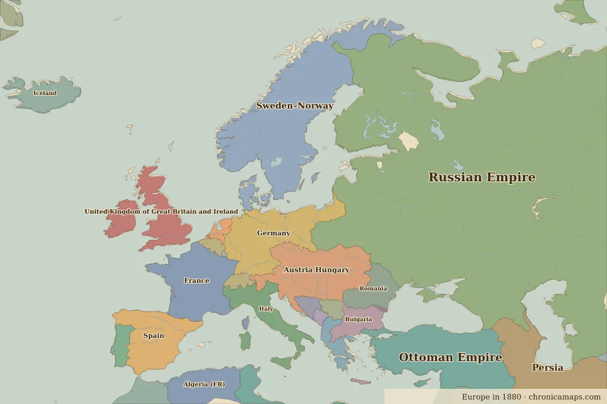
Between 1815 and 1880, 13 states appear on the map of Europe and 14 disappear. Among those that vanish: Austrian Empire, Algiers, Prussia. New on the map: Austria Hungary, Germany, Algeria (FR). Denmark loses the most territory.
Open 1880 in the interactive map
States that disappeared
| State | Area in 1815 |
|---|---|
| Austrian Empire | 600,000 km² |
| Algiers | 430,000 km² |
| Prussia | 260,000 km² |
| Tunis | 100,000 km² |
| Kingdom of the Two Sicilies | 90,000 km² |
| Bavaria | 80,000 km² |
| Tripolitania | 70,000 km² |
| Kingdom of Sardinia | 70,000 km² |
| Cyrenaica | 50,000 km² |
| Papal States | 40,000 km² |
| Hanover | 40,000 km² |
| Venetia | 30,000 km² |
New states on the map
| State | Area in 1880 |
|---|---|
| Austria Hungary | 600,000 km² |
| Germany | 500,000 km² |
| Algeria (FR) | 420,000 km² |
| Italy | 300,000 km² |
| Romania | 200,000 km² |
| Bulgaria | 180,000 km² |
| Greece | 110,000 km² |
| Iceland | 100,000 km² |
| Serbia | 50,000 km² |
| Bosnia-Herzegovina | 50,000 km² |
| Netherlands | 30,000 km² |
| Belgium | 30,000 km² |
States that grew or shrank
| State | Change in area |
|---|---|
| Denmark | −2.18 million km² |
| Ottoman Empire | +890,000 km² |
| Persia | −330,000 km² |
| Morocco | −80,000 km² |
| United Kingdom of Great Britain and Ireland | +30,000 km² |
What happened in between
| Year | Event | Where |
|---|---|---|
| 1827 | Battle of Navarino | Battle of Navarino |
| 1830 | Belgian independence | Brussels |
| 1848 | The “Springtime of Nations” | |
| 1853 | Crimean War | |
| 1861 | Kingdom of Italy proclaimed | |
| 1869 | The Suez Canal opens | Suez Canal |
| 1871 | German Empire proclaimed | Versailles |
| 1878 | Congress of Berlin | Berlin |
Battles of the period
- Battle of Navarino · 1827
- Suez Canal · 1869
- Battle of Sedan · 1870
People of the period
| Lived | Person | |
|---|---|---|
| 1749 – 1832 | Johann Wolfgang von Goethe | Writer |
| 1769 – 1821 | Napoleon Bonaparte | Emperor of the French |
| 1802 – 1885 | Victor Hugo | Writer |
| 1809 – 1882 | Charles Darwin | Naturalist |
| 1815 – 1898 | Otto von Bismarck | Chancellor of Germany |
| 1819 – 1901 | Queen Victoria | Queen of the United Kingdom |
| 1828 – 1910 | Leo Tolstoy | Writer |
| 1856 – 1939 | Sigmund Freud | Founder of psychoanalysis |
| 1870 – 1924 | Vladimir Lenin | Bolshevik leader |
| 1878 – 1953 | Joseph Stalin | Soviet leader |
Questions
How did the map of Europe change between 1815 and 1880?
Between 1815 and 1880, 13 states appear on the map of Europe and 14 disappear. Among those that vanish: Austrian Empire, Algiers, Prussia. New on the map: Austria Hungary, Germany, Algeria (FR). Denmark loses the most territory.
Which states disappeared from the map of Europe between 1815 and 1880?
Austrian Empire, Algiers, Prussia, Tunis, Kingdom of the Two Sicilies, Bavaria, Tripolitania, Kingdom of Sardinia, Cyrenaica, Papal States.
Which new states appeared between 1815 and 1880?
Austria Hungary, Germany, Algeria (FR), Italy, Romania, Bulgaria, Greece, Iceland, Serbia, Bosnia-Herzegovina.
Borders are drawn from the nearest available maps and are approximate.
Last updated 10 November 2026. Sources: border data from historical-basemaps, land and rivers from Natural Earth; texts written for Chronica Maps from standard reference works. How we make the maps.