War and independence in Asia: Asia in 1938 and 1960
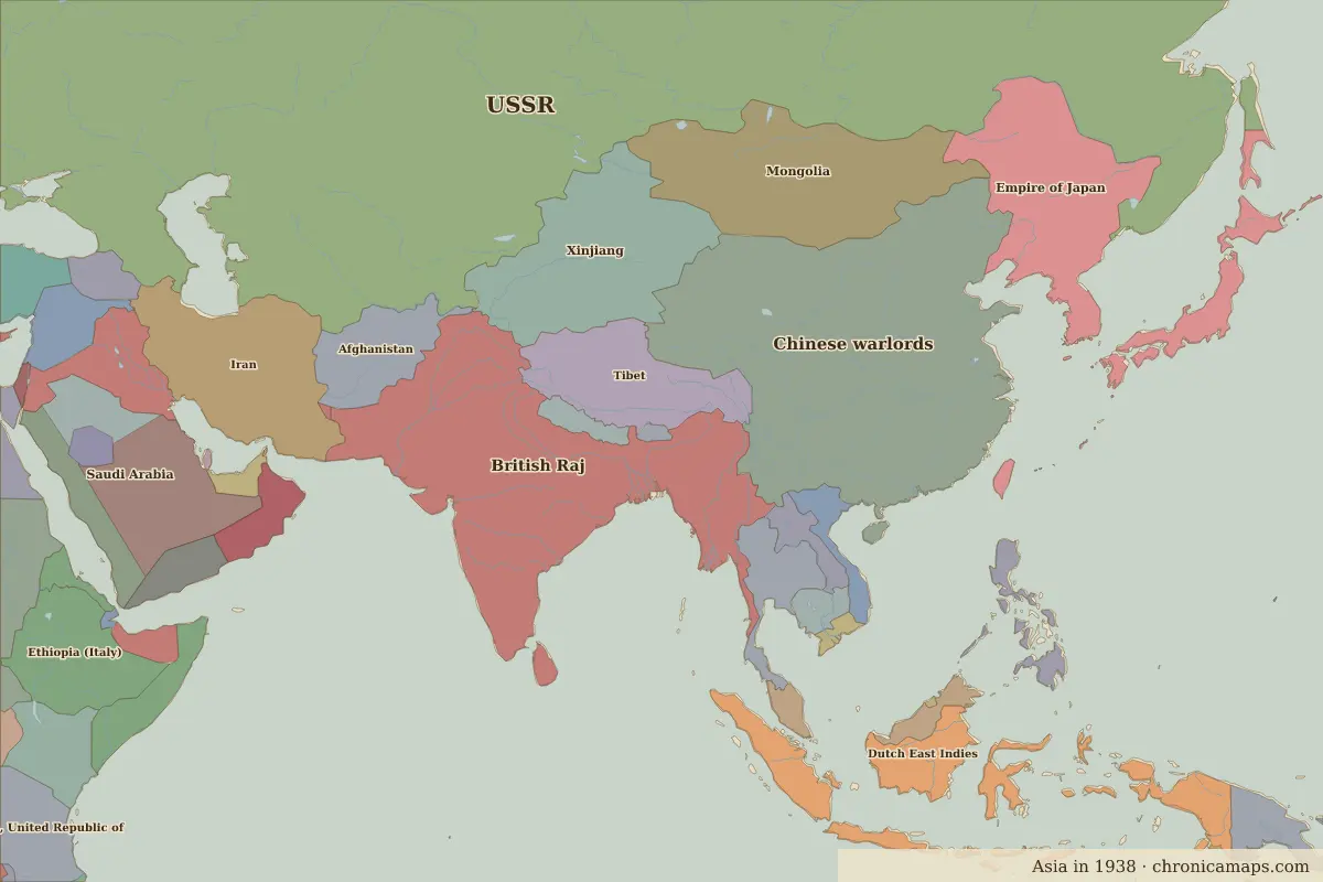
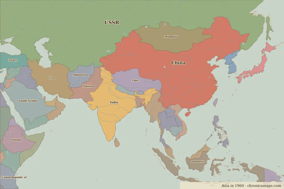
Between 1938 and 1960, 13 states appear on the map of Asia and 12 disappear. Among those that vanish: Chinese warlords, British Raj, Empire of Japan. New on the map: China, Indonesia, Pakistan. India gains the most territory.
Open 1960 in the interactive map
States that disappeared
| State | Area in 1938 |
|---|---|
| Chinese warlords | 5.45 million km² |
| British Raj | 4.81 million km² |
| Empire of Japan | 1.79 million km² |
| Dutch East Indies | 1.70 million km² |
| Xinjiang | 1.63 million km² |
| Siam | 510,000 km² |
| Muscat and Oman | 310,000 km² |
| Oman (British Raj) | 310,000 km² |
| French Indo-China | 250,000 km² |
| Trucial Oman | 100,000 km² |
| Cochin China | 80,000 km² |
| Ceylon | 60,000 km² |
New states on the map
| State | Area in 1960 |
|---|---|
| China | 8.20 million km² |
| Indonesia | 1.70 million km² |
| Pakistan | 960,000 km² |
| Burma | 660,000 km² |
| Thailand | 510,000 km² |
| Japan | 360,000 km² |
| Vietnam | 330,000 km² |
| Oman | 310,000 km² |
| Korea, Democratic People's Republic of | 130,000 km² |
| United Arab Emirates | 100,000 km² |
| Korea, Republic of | 100,000 km² |
| Sri Lanka | 60,000 km² |
States that grew or shrank
| State | Change in area |
|---|---|
| India | +3.20 million km² |
What happened in between
| Year | Event | Where |
|---|---|---|
| 1942 | Fall of Singapore | Singapore |
| 1945 | Atomic bombing of Hiroshima | Hiroshima |
| 1945 | Battles of Iwo Jima and Okinawa | Battle of Okinawa |
| 1947 | Partition and Indian independence | Delhi |
| 1949 | The People's Republic of China is proclaimed | Beijing |
| 1950 | The Incheon landing | Battle of Incheon |
| 1954 | Battle of Dien Bien Phu | Battle of Dien Bien Phu |
Battles of the period
- Battle of Kohima · 1944
- Battle of Iwo Jima · 1945
- Battle of Okinawa · 1945
- Battle of Incheon · 1950
- Battle of Dien Bien Phu · 1954
People of the period
| Lived | Person | |
|---|---|---|
| 1861 – 1941 | Rabindranath Tagore | Poet |
| 1869 – 1948 | Mahatma Gandhi | Leader of Indian independence |
| 1876 – 1948 | Muhammad Ali Jinnah | Founder of Pakistan |
| 1889 – 1964 | Jawaharlal Nehru | First prime minister of India |
| 1890 – 1969 | Ho Chi Minh | Vietnamese revolutionary leader |
Questions
How did the map of Asia change between 1938 and 1960?
Between 1938 and 1960, 13 states appear on the map of Asia and 12 disappear. Among those that vanish: Chinese warlords, British Raj, Empire of Japan. New on the map: China, Indonesia, Pakistan. India gains the most territory.
Which states disappeared from the map of Asia between 1938 and 1960?
Chinese warlords, British Raj, Empire of Japan, Dutch East Indies, Xinjiang, Siam, Muscat and Oman, Oman (British Raj), French Indo-China, Trucial Oman.
Which new states appeared between 1938 and 1960?
China, Indonesia, Pakistan, Burma, Thailand, Japan, Vietnam, Oman, Korea, Democratic People's Republic of, United Arab Emirates.
Borders are drawn from the nearest available maps and are approximate.
Last updated 10 November 2026. Sources: border data from historical-basemaps, land and rivers from Natural Earth; texts written for Chronica Maps from standard reference works. How we make the maps.