The Thirty Years’ War and its aftermath: Europe in 1600 and 1700
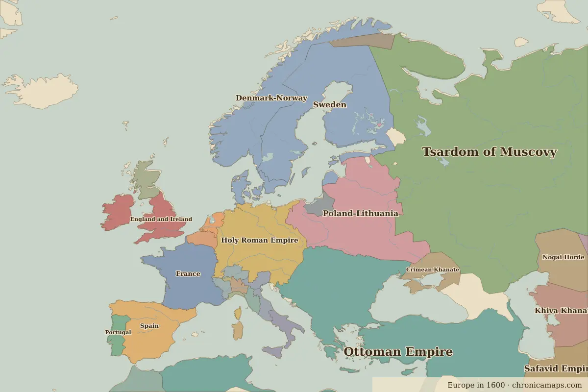
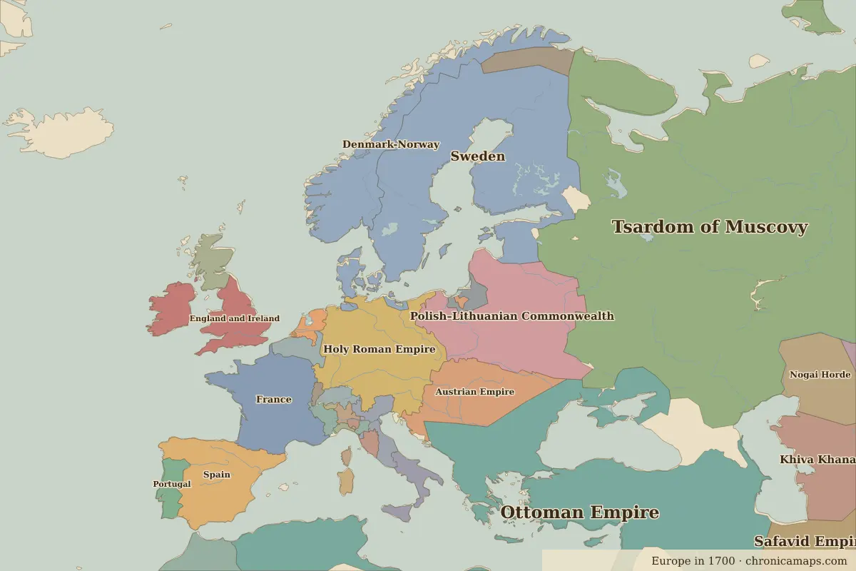
Between 1600 and 1700, 5 states appear on the map of Europe and 6 disappear. Among those that vanish: Poland-Lithuania, Wattasid Morocco, Crimean Khanate. New on the map: Polish–Lithuanian Commonwealth, Austrian Empire, Luxembourg. Sweden gains the most territory.
Open 1700 in the interactive map
States that disappeared
| State | Area in 1600 |
|---|---|
| Poland-Lithuania | 890,000 km² |
| Wattasid Morocco | 360,000 km² |
| Crimean Khanate | 170,000 km² |
| Habsburg Netherlands | 40,000 km² |
| Florence | 40,000 km² |
| Savoy | 30,000 km² |
New states on the map
| State | Area in 1700 |
|---|---|
| Polish–Lithuanian Commonwealth | 700,000 km² |
| Austrian Empire | 420,000 km² |
| Luxembourg | 60,000 km² |
| Sardinia-Piedmont | 30,000 km² |
| Tuscany | 20,000 km² |
States that grew or shrank
| State | Change in area |
|---|---|
| Sweden | +230,000 km² |
| Denmark-Norway | −140,000 km² |
| Holy Roman Empire | −70,000 km² |
What happened in between
| Year | Event | Where |
|---|---|---|
| 1618 | Defenestration of Prague; Thirty Years' War begins | Prague |
| 1632 | Battle of Lützen; Gustavus Adolphus killed | Battle of Lützen |
| 1648 | Peace of Westphalia | Münster |
| 1683 | Second Siege of Vienna | Vienna |
| 1700 | Battle of Narva; the Great Northern War begins | Battle of Narva |
Battles of the period
- Battle of the White Mountain · 1620
- Battle of Lützen · 1632
- Münster · 1648
- Battle of Narva · 1700
People of the period
| Lived | Person | |
|---|---|---|
| 1533 – 1603 | Elizabeth I | Queen of England |
| 1547 – 1616 | Miguel de Cervantes | Writer |
| 1564 – 1616 | William Shakespeare | Playwright and poet |
| 1564 – 1642 | Galileo Galilei | Scientist |
| 1577 – 1640 | Peter Paul Rubens | Painter |
| 1603 – 1659 | Abel Tasman | Navigator |
| 1606 – 1669 | Rembrandt | Painter |
| 1638 – 1715 | Louis XIV | King of France |
| 1643 – 1727 | Isaac Newton | Scientist |
| 1685 – 1750 | Johann Sebastian Bach | Composer |
Questions
How did the map of Europe change between 1600 and 1700?
Between 1600 and 1700, 5 states appear on the map of Europe and 6 disappear. Among those that vanish: Poland-Lithuania, Wattasid Morocco, Crimean Khanate. New on the map: Polish–Lithuanian Commonwealth, Austrian Empire, Luxembourg. Sweden gains the most territory.
Which states disappeared from the map of Europe between 1600 and 1700?
Poland-Lithuania, Wattasid Morocco, Crimean Khanate, Habsburg Netherlands, Florence, Savoy.
Which new states appeared between 1600 and 1700?
Polish–Lithuanian Commonwealth, Austrian Empire, Luxembourg, Sardinia-Piedmont, Tuscany.
Borders are drawn from the nearest available maps and are approximate.
Last updated 10 November 2026. Sources: border data from historical-basemaps, land and rivers from Natural Earth; texts written for Chronica Maps from standard reference works. How we make the maps.