Age of Discovery: world in 1492 and 1600
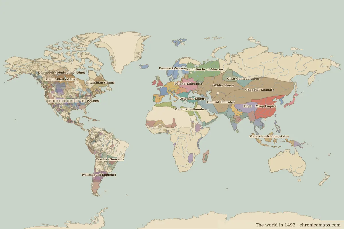
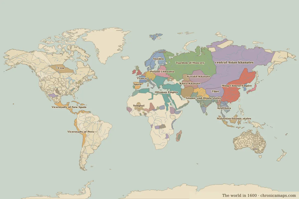
European empires spread across the Americas and to the coasts of Africa and Asia. Between 1492 and 1600, 46 states appear on the map of world and 148 disappear. Among those that vanish: Chagatai Khanate, Ming Empire, White Horde. New on the map: central Asian khanates, Tsardom of Muscovy, Ming Chinese Empire. Ottoman Empire gains the most territory.
Open 1600 in the interactive map
States that disappeared
| State | Area in 1492 |
|---|---|
| Chagatai Khanate | 8.37 million km² |
| Ming Empire | 4.21 million km² |
| White Horde | 2.70 million km² |
| Michif Piyii (Métis) | 2.66 million km² |
| Timurid Emirates | 2.16 million km² |
| Tekohá (Guarani) | 2.04 million km² |
| Grand Duchy of Moscow | 1.97 million km² |
| Emirate of the White Sheep Turks | 1.82 million km² |
| Mamluk Sultanate | 1.47 million km² |
| Golden Horde | 1.19 million km² |
| Wallmapu (Mapuche) | 1.18 million km² |
| 𐓏𐒰𐓓𐒰𐓓𐒷 𐒼𐓂𐓊𐒻 𐓆𐒻𐒿𐒷 𐓀𐒰^𐓓𐒰^(Osage) | 1.04 million km² |
New states on the map
| State | Area in 1600 |
|---|---|
| central Asian khanates | 11.06 million km² |
| Tsardom of Muscovy | 6.85 million km² |
| Ming Chinese Empire | 6.03 million km² |
| Islamic and Hindu states | 1.99 million km² |
| Kazakh Khanate | 1.96 million km² |
| Safavid Empire | 1.61 million km² |
| Mughal Empire | 1.50 million km² |
| Viceroyalty of New Spain | 1.40 million km² |
| Viceroyalty of Peru | 1.17 million km² |
| Khiva Khanate | 940,000 km² |
| Spain | 490,000 km² |
| Nogai Horde | 370,000 km² |
States that grew or shrank
| State | Change in area |
|---|---|
| Ottoman Empire | +4.18 million km² |
| Cree | −770,000 km² |
| Burmese kingdoms | −510,000 km² |
| Malaysian Islamic states | −380,000 km² |
| Bengal | −310,000 km² |
| Adal | +290,000 km² |
| Poland-Lithuania | −290,000 km² |
| Mwenemutapa | −290,000 km² |
| Sweden | +230,000 km² |
| Hadramaut | −220,000 km² |
| Holy Roman Empire | −180,000 km² |
| Crimean Khanate | −150,000 km² |
What happened in between
| Year | Event | Where |
|---|---|---|
| 1498 | Vasco da Gama reaches India | Calicut |
| 1511 | Portugal takes Malacca | Malacca |
| 1514 | Battle of Chaldiran | Battle of Chaldiran |
| 1517 | Luther's Ninety-five Theses | Wittenberg |
| 1521 | Fall of the Aztec Empire | Battle of Fall of Tenochtitlan |
| 1526 | Battle of Mohács | Battle of Mohács |
| 1526 | Battle of Panipat: the Mughal Empire is founded | Battle of Panipat |
| 1529 | First Siege of Vienna | Vienna |
| 1532 | Pizarro captures the Inca emperor | Battle of Cajamarca |
| 1545 | Silver is found at Potosí | Potosí |
| 1552 | Ivan the Terrible takes Kazan | Kazan |
| 1555 | Peace of Augsburg | |
| 1557 | The Portuguese settle in Macau | Macau |
| 1569 | Union of Lublin creates the Polish–Lithuanian Commonwealth | |
| 1571 | Battle of Lepanto | Battle of Lepanto |
| 1588 | Defeat of the Spanish Armada | Battle of Gravelines |
Battles of the period
- Calicut · 1498
- Battle of Chaldiran · 1514
- Wittenberg · 1517
- Battle of Fall of Tenochtitlan · 1521
- Battle of Mohács · 1526
- Battle of Panipat · 1526
- Battle of Cajamarca · 1532
- Battle of Lepanto · 1571
- Battle of Gravelines · 1588
- Battle of Tondibi · 1591
- Battle of Hansando · 1592
- Battle of Myeongnyang · 1597
- Battle of Sekigahara · 1600
People of the period
| Lived | Person | |
|---|---|---|
| c. 1443 – 1538 | Askia Muhammad | Emperor of Songhai |
| 1452 – 1519 | Leonardo da Vinci | Painter and inventor |
| 1471 – 1528 | Albrecht Dürer | Painter and printmaker |
| c. 1478 – 1541 | Francisco Pizarro | Spanish conquistador |
| 1483 – 1530 | Babur | Founder of the Mughal Empire |
| c. 1502 – 1533 | Atahualpa | Sapa Inca |
| 1533 – 1603 | Elizabeth I | Queen of England |
| 1543 – 1616 | Tokugawa Ieyasu | First Tokugawa shogun |
| 1564 – 1616 | William Shakespeare | Playwright and poet |
| 1577 – 1640 | Peter Paul Rubens | Painter |
Questions
How did the map of world change between 1492 and 1600?
Between 1492 and 1600, 46 states appear on the map of world and 148 disappear. Among those that vanish: Chagatai Khanate, Ming Empire, White Horde. New on the map: central Asian khanates, Tsardom of Muscovy, Ming Chinese Empire. Ottoman Empire gains the most territory.
Which states disappeared from the map of world between 1492 and 1600?
Chagatai Khanate, Ming Empire, White Horde, Michif Piyii (Métis), Timurid Emirates, Tekohá (Guarani), Grand Duchy of Moscow, Emirate of the White Sheep Turks, Mamluk Sultanate, Golden Horde.
Which new states appeared between 1492 and 1600?
central Asian khanates, Tsardom of Muscovy, Ming Chinese Empire, Islamic and Hindu states, Kazakh Khanate, Safavid Empire, Mughal Empire, Viceroyalty of New Spain, Viceroyalty of Peru, Khiva Khanate.
Borders are drawn from the nearest available maps and are approximate.
Last updated 10 November 2026. Sources: border data from historical-basemaps, land and rivers from Natural Earth; texts written for Chronica Maps from standard reference works. How we make the maps.