World War I: Europe in 1914 and 1920
Four empires collapse and new states appear across central and eastern Europe. Between 1914 and 1920, 19 states appear on the map of Europe and 8 disappear. Among those that vanish: Ottoman Empire, Persia, Austro-Hungarian Empire. New on the map: Iran, Mesopotamia (GB), Italy. Armenia gains the most territory.
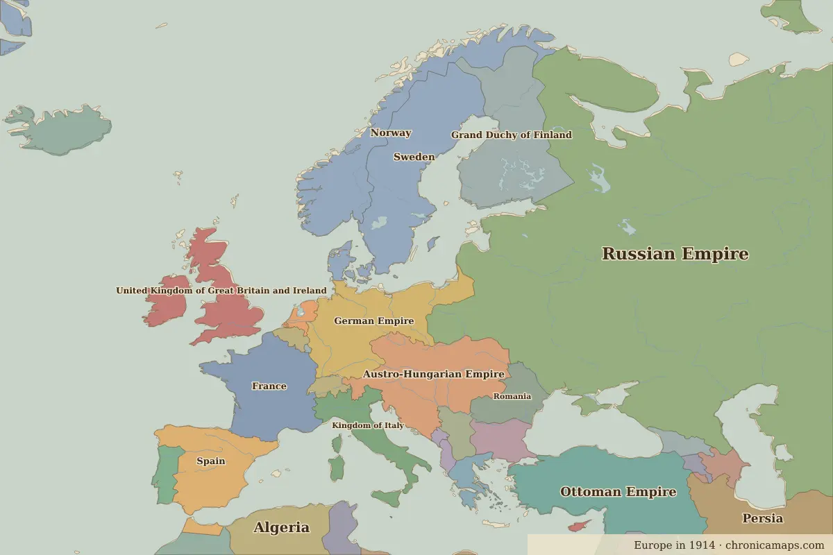
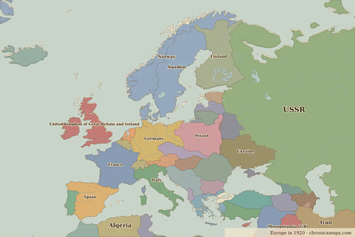
Open 1920 in the interactive map
States that disappeared
| State | Area in 1914 |
|---|---|
| Ottoman Empire | 1.80 million km² |
| Persia | 1.61 million km² |
| Austro-Hungarian Empire | 650,000 km² |
| German Empire | 520,000 km² |
| Grand Duchy of Finland | 360,000 km² |
| Kingdom of Italy | 290,000 km² |
| Serbia | 100,000 km² |
| Spanish Morocco | 40,000 km² |
New states on the map
| State | Area in 1920 |
|---|---|
| Iran | 1.59 million km² |
| Mesopotamia (GB) | 550,000 km² |
| Italy | 510,000 km² |
| Ukraine | 430,000 km² |
| Germany | 430,000 km² |
| Poland | 390,000 km² |
| Finland | 370,000 km² |
| Syria (France) | 320,000 km² |
| Ottoman Sultanate | 250,000 km² |
| Yugoslavia | 240,000 km² |
| Czechoslovakia | 140,000 km² |
| White Russia | 130,000 km² |
States that grew or shrank
| State | Change in area |
|---|---|
| Armenia | +130,000 km² |
| Romania | +110,000 km² |
| Greece | +50,000 km² |
| Azerbaijan | +40,000 km² |
| Bulgaria | −40,000 km² |
| Morocco | +40,000 km² |
What happened in between
| Year | Event | Where |
|---|---|---|
| 1915 | Gallipoli campaign | Gallipoli Campaign |
| 1916 | Verdun and the Somme | Battle of Verdun |
| 1917 | Russian October Revolution | St Petersburg |
| 1918 | WWI ends; empires collapse | |
| 1919 | Treaty of Versailles | Versailles |
Battles of the period
- Gallipoli Campaign · 1915
- Battle of Verdun · 1916
- Battle of the Somme · 1916
- Versailles · 1919
People of the period
| Lived | Person | |
|---|---|---|
| 1856 – 1939 | Sigmund Freud | Founder of psychoanalysis |
| 1867 – 1934 | Marie Curie | Physicist and chemist |
| 1870 – 1924 | Vladimir Lenin | Bolshevik leader |
| 1874 – 1965 | Winston Churchill | British prime minister |
| 1878 – 1953 | Joseph Stalin | Soviet leader |
| 1879 – 1955 | Albert Einstein | Physicist |
| 1881 – 1938 | Mustafa Kemal Atatürk | Founder of the Republic of Turkey |
| 1883 – 1924 | Franz Kafka | Writer |
| 1890 – 1970 | Charles de Gaulle | President of France |
| 1918 – 1970 | Gamal Abdel Nasser | President of Egypt |
Questions
How did the map of Europe change between 1914 and 1920?
Between 1914 and 1920, 19 states appear on the map of Europe and 8 disappear. Among those that vanish: Ottoman Empire, Persia, Austro-Hungarian Empire. New on the map: Iran, Mesopotamia (GB), Italy. Armenia gains the most territory.
Which states disappeared from the map of Europe between 1914 and 1920?
Ottoman Empire, Persia, Austro-Hungarian Empire, German Empire, Grand Duchy of Finland, Kingdom of Italy, Serbia, Spanish Morocco.
Which new states appeared between 1914 and 1920?
Iran, Mesopotamia (GB), Italy, Ukraine, Germany, Poland, Finland, Syria (France), Ottoman Sultanate, Yugoslavia.
Borders are drawn from the nearest available maps and are approximate.
Last updated 10 November 2026. Sources: border data from historical-basemaps, land and rivers from Natural Earth; texts written for Chronica Maps from standard reference works. How we make the maps.