Fall of Constantinople and the Ottoman advance: Europe in 1400 and 1500
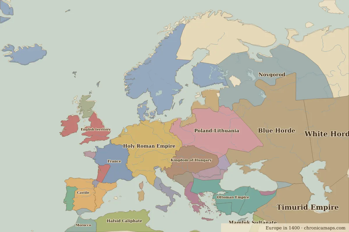
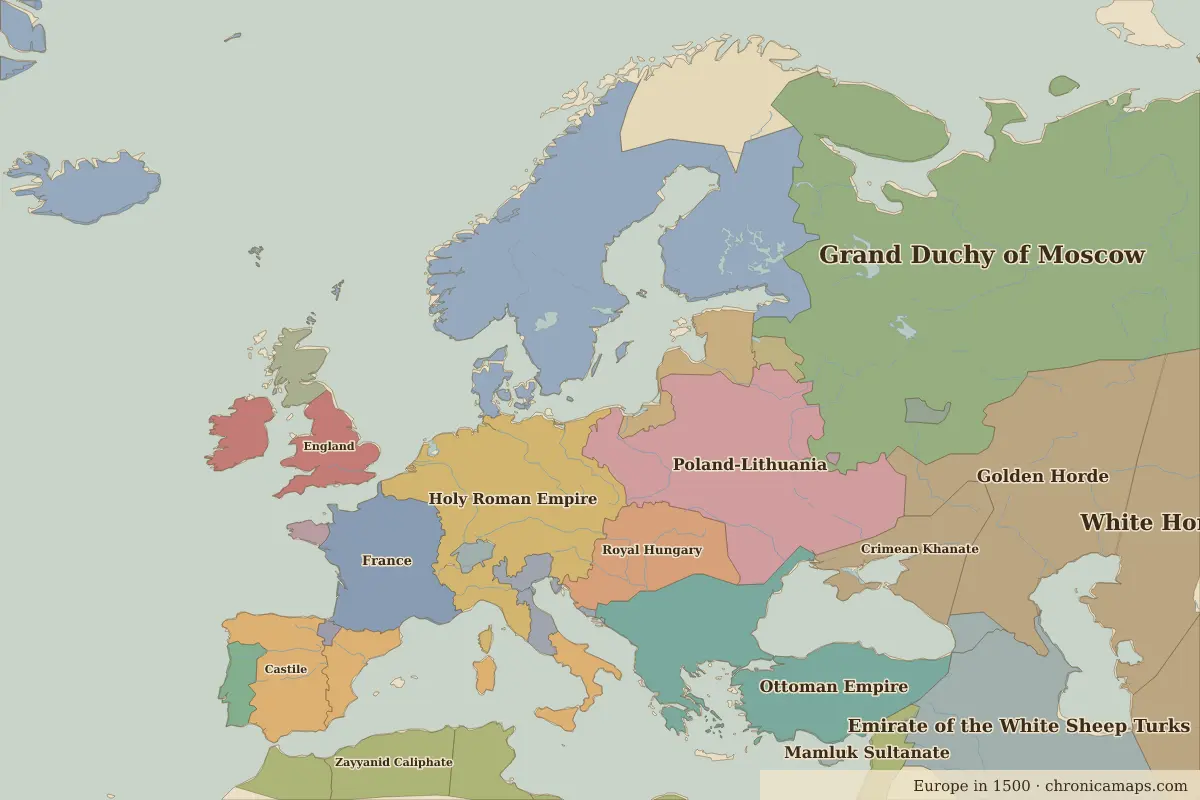
Between 1400 and 1500, 11 states appear on the map of Europe and 17 disappear. Among those that vanish: Blue Horde, Novgorod, Kingdom of Hungary. New on the map: Grand Duchy of Moscow, Emirate of the White Sheep Turks, Golden Horde. Ottoman Empire gains the most territory.
Open 1500 in the interactive map
States that disappeared
| State | Area in 1400 |
|---|---|
| Blue Horde | 1.83 million km² |
| Novgorod | 880,000 km² |
| Kingdom of Hungary | 400,000 km² |
| Castile | 320,000 km² |
| English territory | 290,000 km² |
| Morocco | 250,000 km² |
| Seljuk Caliphate | 240,000 km² |
| Byzantine Empire | 130,000 km² |
| Sicily | 90,000 km² |
| Bosnia | 80,000 km² |
| Beylik of Aydin | 70,000 km² |
| Principality of Wallachia | 70,000 km² |
New states on the map
| State | Area in 1500 |
|---|---|
| Grand Duchy of Moscow | 2.77 million km² |
| Emirate of the White Sheep Turks | 1.82 million km² |
| Golden Horde | 1.09 million km² |
| Royal Hungary | 360,000 km² |
| Castile | 350,000 km² |
| Crimean Khanate | 330,000 km² |
| Zayyanid Caliphate | 320,000 km² |
| England | 230,000 km² |
| Wattasid Caliphate | 150,000 km² |
| Pskov | 30,000 km² |
| Swiss Confederation | 30,000 km² |
States that grew or shrank
| State | Change in area |
|---|---|
| Ottoman Empire | +700,000 km² |
| Hafsid Caliphate | −460,000 km² |
| Kalmar Union | +250,000 km² |
| Poland-Lithuania | +120,000 km² |
| Aragón | +120,000 km² |
| France | +60,000 km² |
| Venice | +40,000 km² |
| Georgia | +20,000 km² |
What happened in between
| Year | Event | Where |
|---|---|---|
| 1402 | Battle of Ankara | Battle of Ankara |
| 1410 | Battle of Grunwald | Battle of Grunwald |
| 1415 | Battle of Agincourt | Battle of Agincourt |
| 1429 | Joan of Arc relieves Orléans | Battle of Orléans |
| 1444 | Battle of Varna | Battle of Varna |
| 1453 | Fall of Constantinople | Istanbul |
| 1455 | Gutenberg prints the Bible | |
| 1480 | Moscow throws off the Golden Horde | Moscow |
| 1492 | Fall of Granada; Columbus sets sail | Granada |
Battles of the period
- Battle of Ankara · 1402
- Battle of Grunwald · 1410
- Battle of Agincourt · 1415
- Battle of Orléans · 1429
- Battle of Varna · 1444
People of the period
| Lived | Person | |
|---|---|---|
| 1332 – 1406 | Ibn Khaldun | Historian |
| 1394 – 1460 | Henry the Navigator | Portuguese prince |
| c. 1412 – 1431 | Joan of Arc | French national heroine |
| 1449 – 1492 | Lorenzo de’ Medici | Ruler of Florence |
| 1452 – 1519 | Leonardo da Vinci | Painter and inventor |
| 1469 – 1527 | Niccolò Machiavelli | Political thinker |
| 1473 – 1543 | Nicolaus Copernicus | Astronomer |
| c. 1478 – 1541 | Francisco Pizarro | Spanish conquistador |
| 1483 – 1546 | Martin Luther | Reformer |
| 1485 – 1547 | Hernán Cortés | Spanish conquistador |
Questions
How did the map of Europe change between 1400 and 1500?
Between 1400 and 1500, 11 states appear on the map of Europe and 17 disappear. Among those that vanish: Blue Horde, Novgorod, Kingdom of Hungary. New on the map: Grand Duchy of Moscow, Emirate of the White Sheep Turks, Golden Horde. Ottoman Empire gains the most territory.
Which states disappeared from the map of Europe between 1400 and 1500?
Blue Horde, Novgorod, Kingdom of Hungary, Castile, English territory, Morocco, Seljuk Caliphate, Byzantine Empire, Sicily, Bosnia.
Which new states appeared between 1400 and 1500?
Grand Duchy of Moscow, Emirate of the White Sheep Turks, Golden Horde, Royal Hungary, Castile, Crimean Khanate, Zayyanid Caliphate, England, Wattasid Caliphate, Pskov.
Borders are drawn from the nearest available maps and are approximate.
Last updated 10 November 2026. Sources: border data from historical-basemaps, land and rivers from Natural Earth; texts written for Chronica Maps from standard reference works. How we make the maps.