Map of Europe in 1500
This border map shows Europe and the Mediterranean in 1500 (era: Renaissance & Reformation). The largest states on the map were Kalmar Union, Grand Duchy of Moscow and White Horde. The map stays in use until the next border change recorded in 1600.
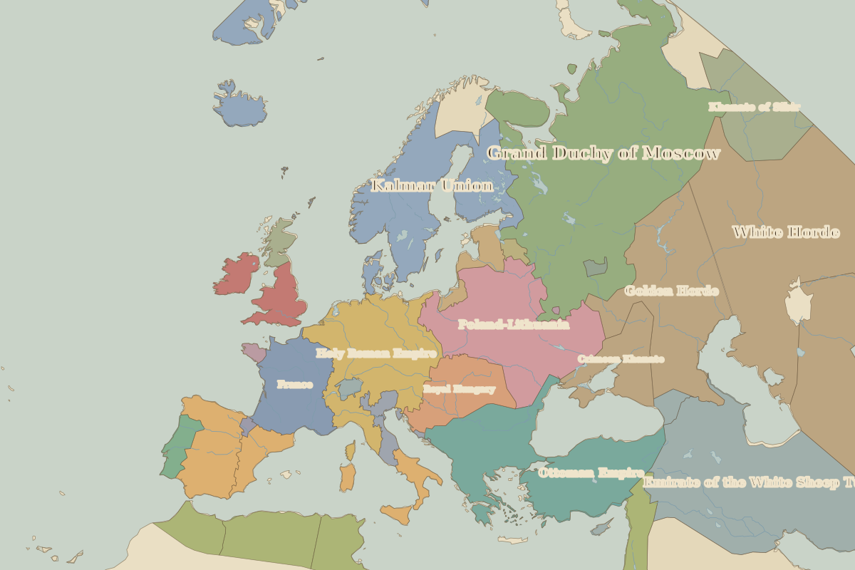
Open Europe in 1500 in the interactive map
States on the map in 1500
Areas are approximate and cover each state's whole territory, including land outside the map frame.
| State | Approx. area |
|---|---|
| Kalmar Union | 3.07 million km² |
| Grand Duchy of Moscow | 2.77 million km² |
| White Horde | 2.63 million km² |
| Timurid Emirates | 2.16 million km² |
| Emirate of the White Sheep Turks | 1.82 million km² |
| Mamluk Sultanate | 1.47 million km² |
| Golden Horde | 1.09 million km² |
| Ottoman Empire | 1.09 million km² |
| Poland-Lithuania | 1.02 million km² |
| Holy Roman Empire | 850,000 km² |
| Oirat Confederation | 810,000 km² |
| Khanate of Sibir | 660,000 km² |
| France | 460,000 km² |
| Royal Hungary | 360,000 km² |
| Castile | 350,000 km² |
| Crimean Khanate | 330,000 km² |
| Zayyanid Caliphate | 320,000 km² |
| Aragón | 250,000 km² |
| Hafsid Caliphate | 230,000 km² |
| England | 230,000 km² |
| Wattasid Caliphate | 150,000 km² |
| Teutonic Knights | 130,000 km² |
| Portugal | 90,000 km² |
| Scotland | 60,000 km² |
| Georgia | 50,000 km² |
Rulers in 1500
| Realm | Ruler | Reign |
|---|---|---|
| Franks / HRE / Germany | Maximilian I | 1493–1519 |
| France | Louis XII | 1498–1515 |
| England / UK | Henry VII | 1485–1509 |
| Spain | The Catholic Monarchs | 1479–1516 |
| Rus' / Russia | Ivan III | 1462–1505 |
| Ottomans / Turkey | Bayezid II | 1481–1512 |
Key events, 1500 to 1599
| Year | Event | Where |
|---|---|---|
| 1517 | Luther's Ninety-five Theses | Wittenberg |
| 1526 | Battle of Mohács | Battle of Mohács |
| 1529 | First Siege of Vienna | Vienna |
| 1552 | Ivan the Terrible takes Kazan | Kazan |
| 1555 | Peace of Augsburg | |
| 1569 | Union of Lublin creates the Polish–Lithuanian Commonwealth | |
| 1571 | Battle of Lepanto | Battle of Lepanto |
| 1588 | Defeat of the Spanish Armada | Battle of Gravelines |
Battles and sites in this period
- Wittenberg · 1517
- Battle of Mohács · 1526
- Battle of Lepanto · 1571
- Battle of Gravelines · 1588
← Europe in 1492Europe in 1600 →
Part of the era: Renaissance & Reformation. See also the world in 1500.