Map of Europe in 1492
This border map shows Europe and the Mediterranean in 1492 (era: Renaissance & Reformation). The largest states within the map area were White Horde, Grand Duchy of Moscow and Emirate of the White Sheep Turks. The map stays in use until the next border change recorded in 1500.
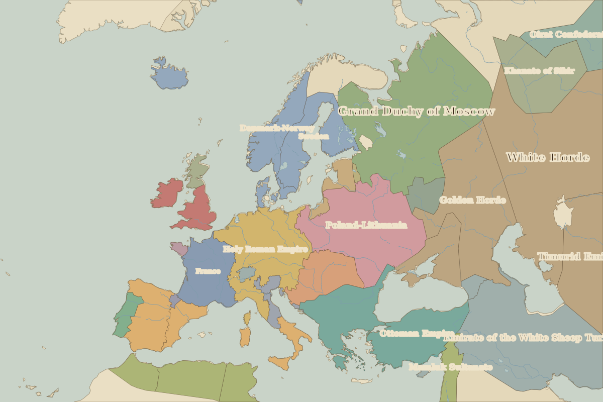
Open Europe in 1492 in the interactive map
States on the map in 1492
Areas are approximate and count only territory inside the map area.
| State | Approx. area on map |
|---|---|
| White Horde | 2.19 million km² |
| Grand Duchy of Moscow | 1.97 million km² |
| Emirate of the White Sheep Turks | 1.82 million km² |
| Mamluk Sultanate | 1.37 million km² |
| Timurid Emirates | 1.20 million km² |
| Golden Horde | 1.19 million km² |
| Poland-Lithuania | 1.18 million km² |
| Ottoman Empire | 1.09 million km² |
| Holy Roman Empire | 850,000 km² |
| Denmark-Norway | 550,000 km² |
| Khanate of Sibir | 510,000 km² |
| France | 460,000 km² |
| Sweden | 450,000 km² |
| Royal Hungary | 360,000 km² |
| Castile | 350,000 km² |
| Crimean Khanate | 330,000 km² |
| Zayyanid Caliphate | 320,000 km² |
| Chagatai Khanate | 300,000 km² |
| Aragón | 250,000 km² |
| Hafsid Caliphate | 230,000 km² |
| England | 230,000 km² |
| Wattasid Caliphate | 150,000 km² |
| Ryazan | 150,000 km² |
| Teutonic Knights | 130,000 km² |
| Muscat | 120,000 km² |
Rulers in 1492
| Realm | Ruler | Reign |
|---|---|---|
| Franks / HRE / Germany | Frederick III | 1440–1493 |
| France | Charles VIII | 1483–1498 |
| England / UK | Henry VII | 1485–1509 |
| Spain | The Catholic Monarchs | 1479–1516 |
| Rus' / Russia | Ivan III | 1462–1505 |
| Ottomans / Turkey | Bayezid II | 1481–1512 |
Key events, 1492 to 1499
| Year | Event | Where |
|---|---|---|
| 1492 | Fall of Granada; Columbus sets sail | Granada |
← Europe in 1400Europe in 1500 →
Part of the era: Renaissance & Reformation.