Independence in the Americas: Americas in 1783 and 1880
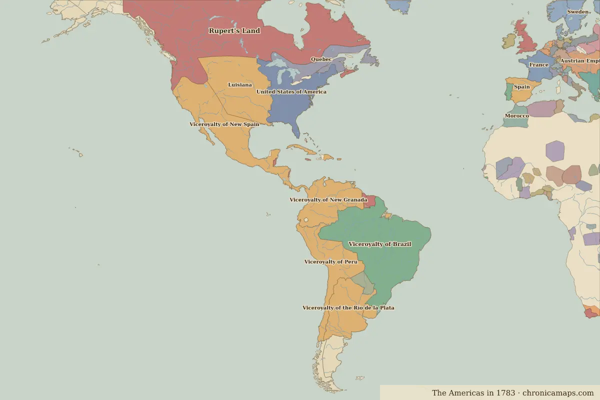
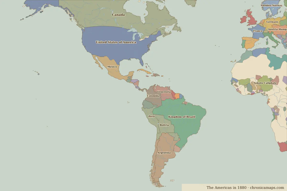
Between 1783 and 1880, 20 states appear on the map of Americas and 9 disappear. Among those that vanish: Viceroyalty of Brazil, Rupert's Land, Viceroyalty of New Spain. New on the map: Canada, Kingdom of Brazil, Argentina. United States of America gains the most territory.
Open 1880 in the interactive map
States that disappeared
| State | Area in 1783 |
|---|---|
| Viceroyalty of Brazil | 8.10 million km² |
| Rupert's Land | 7.85 million km² |
| Viceroyalty of New Spain | 4.09 million km² |
| Luisiana | 3.14 million km² |
| Viceroyalty of New Granada | 3.09 million km² |
| Viceroyalty of Peru | 2.80 million km² |
| Viceroyalty of the Río de la Plata | 2.36 million km² |
| Quebec | 950,000 km² |
| Acadian Peninsula (UK) | 40,000 km² |
New states on the map
| State | Area in 1880 |
|---|---|
| Canada | 9.37 million km² |
| Kingdom of Brazil | 8.03 million km² |
| Argentina | 2.78 million km² |
| Mexico | 1.92 million km² |
| Bolivia | 1.48 million km² |
| Colombia | 1.40 million km² |
| Venezuela | 1.16 million km² |
| Peru | 1.10 million km² |
| Ecuador | 470,000 km² |
| Chile | 460,000 km² |
| Uruguay | 170,000 km² |
| Dutch Guiana | 150,000 km² |
States that grew or shrank
| State | Change in area |
|---|---|
| United States of America | +7.07 million km² |
| British Guiana | −80,000 km² |
| Paraguay | −80,000 km² |
What happened in between
| Year | Event | Where |
|---|---|---|
| 1804 | Haiti becomes independent | |
| 1808 | The Portuguese court moves to Rio | Rio de Janeiro |
| 1810 | The Mexican War of Independence begins | |
| 1819 | Battle of Boyacá | Battle of Boyacá |
| 1822 | Brazil becomes independent | Rio de Janeiro |
| 1824 | Battle of Ayacucho | Battle of Ayacucho |
| 1836 | Battle of the Alamo | Battle of The Alamo |
| 1848 | Gold is found in California | San Francisco |
| 1861 | The American Civil War begins | |
| 1863 | Battle of Gettysburg | Battle of Gettysburg |
| 1865 | Lincoln is assassinated | Washington, D.C. |
Battles of the period
- Battle of Boyacá · 1819
- Battle of Ayacucho · 1824
- Battle of The Alamo · 1836
- Battle of Gettysburg · 1863
People of the period
| Lived | Person | |
|---|---|---|
| 1706 – 1790 | Benjamin Franklin | Scientist and statesman |
| 1732 – 1799 | George Washington | First president of the United States |
| 1743 – 1826 | Thomas Jefferson | Third president of the United States |
| 1746 – 1792 | Tiradentes | Forerunner of Brazilian independence |
| 1778 – 1850 | José de San Martín | Leader of South American independence |
| 1783 – 1830 | Simón Bolívar | Liberator of South America |
| 1806 – 1872 | Benito Juárez | President of Mexico |
| 1809 – 1865 | Abraham Lincoln | Sixteenth president of the United States |
| 1825 – 1891 | Pedro II of Brazil | Emperor of Brazil |
| 1853 – 1895 | José Martí | Cuban poet and independence leader |
Questions
How did the map of Americas change between 1783 and 1880?
Between 1783 and 1880, 20 states appear on the map of Americas and 9 disappear. Among those that vanish: Viceroyalty of Brazil, Rupert's Land, Viceroyalty of New Spain. New on the map: Canada, Kingdom of Brazil, Argentina. United States of America gains the most territory.
Which states disappeared from the map of Americas between 1783 and 1880?
Viceroyalty of Brazil, Rupert's Land, Viceroyalty of New Spain, Luisiana, Viceroyalty of New Granada, Viceroyalty of Peru, Viceroyalty of the Río de la Plata, Quebec, Acadian Peninsula (UK).
Which new states appeared between 1783 and 1880?
Canada, Kingdom of Brazil, Argentina, Mexico, Bolivia, Colombia, Venezuela, Peru, Ecuador, Chile.
Borders are drawn from the nearest available maps and are approximate.
Last updated 10 November 2026. Sources: border data from historical-basemaps, land and rivers from Natural Earth; texts written for Chronica Maps from standard reference works. How we make the maps.