Europe before the First World War: Europe in 1880 and 1914
Between 1880 and 1914, 12 states appear on the map of Europe and 6 disappear. Among those that vanish: Sweden–Norway, Austria Hungary, Germany. New on the map: Austro-Hungarian Empire, German Empire, Sweden. Ottoman Empire loses the most territory.
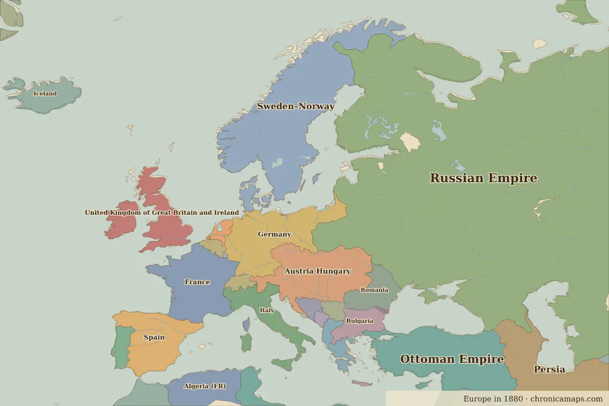
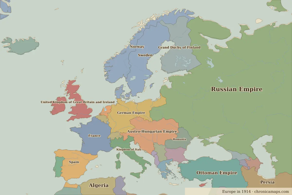
Open 1914 in the interactive map
States that disappeared
| State | Area in 1880 |
|---|---|
| Sweden–Norway | 780,000 km² |
| Austria Hungary | 600,000 km² |
| Germany | 500,000 km² |
| Algeria (FR) | 420,000 km² |
| Italy | 300,000 km² |
| Bosnia-Herzegovina | 50,000 km² |
New states on the map
| State | Area in 1914 |
|---|---|
| Austro-Hungarian Empire | 650,000 km² |
| German Empire | 520,000 km² |
| Sweden | 440,000 km² |
| Grand Duchy of Finland | 360,000 km² |
| Norway | 350,000 km² |
| Kingdom of Italy | 290,000 km² |
| Tunisia | 160,000 km² |
| Azerbaijan | 90,000 km² |
| Georgia | 70,000 km² |
| Spanish Morocco | 40,000 km² |
| Armenia | 30,000 km² |
| Albania | 30,000 km² |
States that grew or shrank
| State | Change in area |
|---|---|
| Ottoman Empire | −1.36 million km² |
| Persia | −170,000 km² |
| Spain | −110,000 km² |
| Serbia | +40,000 km² |
| Morocco | −40,000 km² |
| Bulgaria | −30,000 km² |
What happened in between
| Year | Event | Where |
|---|---|---|
| 1905 | Norway fully independent | Oslo |
| 1914 | Sarajevo assassination; First World War begins | Sarajevo |
Battles of the period
- Sarajevo · 1914
- Battle of Tannenberg · 1914
People of the period
| Lived | Person | |
|---|---|---|
| 1802 – 1885 | Victor Hugo | Writer |
| 1807 – 1882 | Giuseppe Garibaldi | Leader of Italian unification |
| 1815 – 1898 | Otto von Bismarck | Chancellor of Germany |
| 1819 – 1901 | Queen Victoria | Queen of the United Kingdom |
| 1828 – 1910 | Leo Tolstoy | Writer |
| 1856 – 1939 | Sigmund Freud | Founder of psychoanalysis |
| 1867 – 1934 | Marie Curie | Physicist and chemist |
| 1874 – 1965 | Winston Churchill | British prime minister |
| 1879 – 1955 | Albert Einstein | Physicist |
| 1883 – 1924 | Franz Kafka | Writer |
Questions
How did the map of Europe change between 1880 and 1914?
Between 1880 and 1914, 12 states appear on the map of Europe and 6 disappear. Among those that vanish: Sweden–Norway, Austria Hungary, Germany. New on the map: Austro-Hungarian Empire, German Empire, Sweden. Ottoman Empire loses the most territory.
Which states disappeared from the map of Europe between 1880 and 1914?
Sweden–Norway, Austria Hungary, Germany, Algeria (FR), Italy, Bosnia-Herzegovina.
Which new states appeared between 1880 and 1914?
Austro-Hungarian Empire, German Empire, Sweden, Grand Duchy of Finland, Norway, Kingdom of Italy, Tunisia, Azerbaijan, Georgia, Spanish Morocco.
Borders are drawn from the nearest available maps and are approximate.
Last updated 10 November 2026. Sources: border data from historical-basemaps, land and rivers from Natural Earth; texts written for Chronica Maps from standard reference works. How we make the maps.