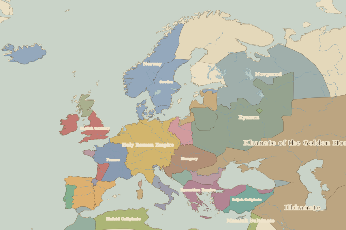
Map of Europe in 1300
This border map shows Europe and the Mediterranean in 1300 (era: Late Middle Ages). The largest states on the map were Khanate of the Golden Horde, Ilkhanate and Chagatai Khanate. The map stays in use until the next border change recorded in 1400.
Open Europe in 1300 in the interactive map
States on the map in 1300
Areas are approximate and cover each state's whole territory, including land outside the map frame.
| State | Approx. area |
|---|---|
| Khanate of the Golden Horde | 5.25 million km² |
| Ilkhanate | 3.77 million km² |
| Chagatai Khanate | 3.31 million km² |
| Ryazan | 1.31 million km² |
| Mamluk Sultanate | 1.24 million km² |
| Holy Roman Empire | 920,000 km² |
| Novgorod | 910,000 km² |
| Hafsid Caliphate | 680,000 km² |
| Norway | 490,000 km² |
| Byzantine Empire | 430,000 km² |
| Hungary | 400,000 km² |
| France | 390,000 km² |
| Seljuk Caliphate | 340,000 km² |
| Castile | 320,000 km² |
| English territory | 290,000 km² |
| Morocco | 250,000 km² |
| Sweden | 210,000 km² |
| Lithuania | 140,000 km² |
| Poland | 140,000 km² |
| Aragón | 130,000 km² |
| Teutonic Knights | 120,000 km² |
| Bulgar Khanate | 120,000 km² |
| Portugal | 90,000 km² |
| Sicily | 90,000 km² |
| Raška | 80,000 km² |
Rulers in 1300
| Realm | Ruler | Reign |
|---|---|---|
| Byzantium | Andronikos II | 1282–1328 |
| Franks / HRE / Germany | Adolf / Albert I | 1292–1308 |
| France | Philip IV | 1285–1314 |
| England / UK | Edward I | 1272–1307 |
| Rus' / Russia | Golden Horde overlordship | 1240–1324 |
| Ottomans / Turkey | Osman I | 1299–1324 |
Key events, 1300 to 1399
| Year | Event | Where |
|---|---|---|
| 1337 | The Hundred Years' War begins | |
| 1347 | The Black Death reaches Europe | |
| 1380 | Battle of Kulikovo | Battle of Kulikovo |
| 1386 | Union of Krewo: Poland and Lithuania joined by marriage | Vilnius |
| 1389 | Battle of Kosovo | Battle of Kosovo |
| 1396 | Battle of Nicopolis | Battle of Nicopolis |
| 1397 | Kalmar Union formed | Kalmar |
Battles and sites in this period
- Battle of Crécy · 1346
- Battle of Kulikovo · 1380
- Battle of Kosovo · 1389
- Battle of Nicopolis · 1396
- Kalmar · 1397
← Europe in 1200Europe in 1400 →
Part of the era: Late Middle Ages. See also the world in 1300.