Napoleonic Europe: Europe in 1783 and 1815
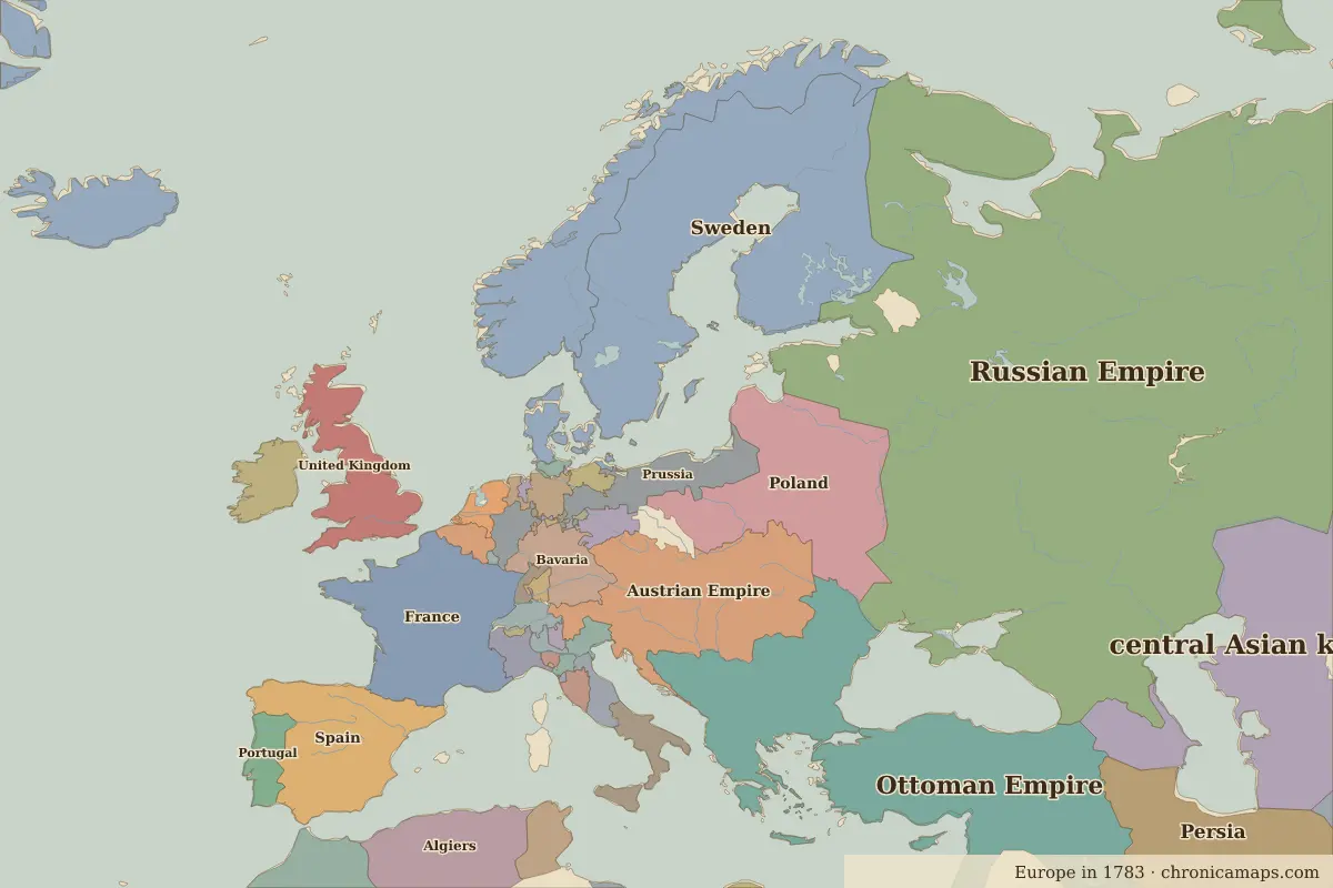
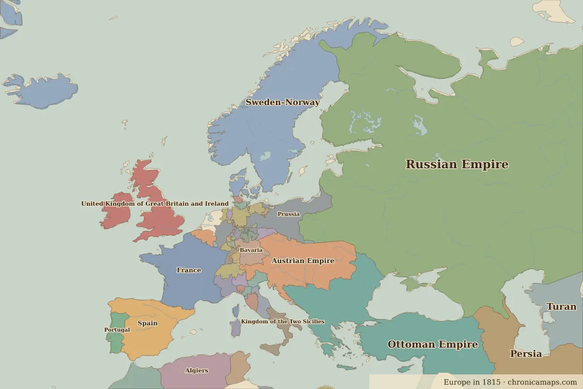
From the eve of the French Revolution to the Congress of Vienna. Between 1783 and 1815, 3 states appear on the map of Europe and 6 disappear. Among those that vanish: Sweden, Poland, Kingdom of Ireland. New on the map: Sweden–Norway, United Kingdom of Great Britain and Ireland, Switzerland. Ottoman Empire loses the most territory.
Open 1815 in the interactive map
States that disappeared
| State | Area in 1783 |
|---|---|
| Sweden | 750,000 km² |
| Poland | 550,000 km² |
| Kingdom of Ireland | 80,000 km² |
| Swiss Confederation | 30,000 km² |
| Netherlands | 30,000 km² |
| Austrian Netherlands | 30,000 km² |
New states on the map
| State | Area in 1815 |
|---|---|
| Sweden–Norway | 780,000 km² |
| United Kingdom of Great Britain and Ireland | 290,000 km² |
| Switzerland | 40,000 km² |
States that grew or shrank
| State | Change in area |
|---|---|
| Ottoman Empire | −820,000 km² |
| Prussia | +80,000 km² |
| Bavaria | −40,000 km² |
| Hanover | +40,000 km² |
| Mecklenburg-Strelitz | −40,000 km² |
| Kingdom of Sardinia | +20,000 km² |
| Saxony | −20,000 km² |
What happened in between
| Year | Event | Where |
|---|---|---|
| 1789 | French Revolution | Paris |
| 1795 | Third Partition of Poland; Poland disappears | Warsaw |
| 1805 | Austerlitz and Trafalgar | Battle of Austerlitz |
| 1806 | Holy Roman Empire dissolved | Vienna |
| 1809 | Finland passes to Russia | Turku |
| 1812 | Napoleon invades Russia | Battle of Borodino |
| 1815 | Waterloo; Congress of Vienna | Battle of Waterloo |
Battles of the period
- Battle of Austerlitz · 1805
- Battle of Trafalgar · 1805
- Battle of Borodino · 1812
- Battle of Leipzig · 1813
- Battle of Waterloo · 1815
People of the period
| Lived | Person | |
|---|---|---|
| 1724 – 1804 | Immanuel Kant | Philosopher |
| 1729 – 1796 | Catherine the Great | Empress of Russia |
| 1749 – 1832 | Johann Wolfgang von Goethe | Writer |
| 1756 – 1791 | Wolfgang Amadeus Mozart | Composer |
| 1769 – 1849 | Muhammad Ali Pasha | Ruler of Egypt |
| 1770 – 1827 | Ludwig van Beethoven | Composer |
| 1802 – 1885 | Victor Hugo | Writer |
| 1807 – 1882 | Giuseppe Garibaldi | Leader of Italian unification |
| 1809 – 1882 | Charles Darwin | Naturalist |
| 1810 – 1849 | Frédéric Chopin | Composer and pianist |
Questions
How did the map of Europe change between 1783 and 1815?
Between 1783 and 1815, 3 states appear on the map of Europe and 6 disappear. Among those that vanish: Sweden, Poland, Kingdom of Ireland. New on the map: Sweden–Norway, United Kingdom of Great Britain and Ireland, Switzerland. Ottoman Empire loses the most territory.
Which states disappeared from the map of Europe between 1783 and 1815?
Sweden, Poland, Kingdom of Ireland, Swiss Confederation, Netherlands, Austrian Netherlands.
Which new states appeared between 1783 and 1815?
Sweden–Norway, United Kingdom of Great Britain and Ireland, Switzerland.
Borders are drawn from the nearest available maps and are approximate.
Last updated 10 November 2026. Sources: border data from historical-basemaps, land and rivers from Natural Earth; texts written for Chronica Maps from standard reference works. How we make the maps.