The Spanish conquest: Americas in 1492 and 1600
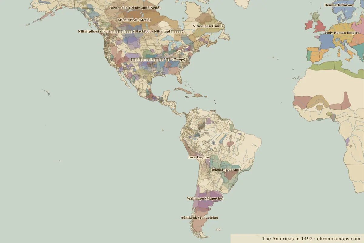
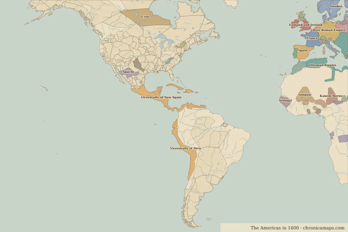
Between 1492 and 1600, 9 states appear on the map of Americas and 100 disappear. Among those that vanish: Michif Piyii (Métis), Tekohá (Guarani), Wallmapu (Mapuche). New on the map: Viceroyalty of New Spain, Viceroyalty of Peru, Apache. Cree loses the most territory.
Open 1600 in the interactive map
States that disappeared
| State | Area in 1492 |
|---|---|
| Michif Piyii (Métis) | 2.66 million km² |
| Tekohá (Guarani) | 2.04 million km² |
| Wallmapu (Mapuche) | 1.18 million km² |
| 𐓏𐒰𐓓𐒰𐓓𐒷 𐒼𐓂𐓊𐒻 𐓆𐒻𐒿𐒷 𐓀𐒰^𐓓𐒰^(Osage) | 1.04 million km² |
| Kiikaapoi (Kickapoo) | 940,000 km² |
| Günün a atük (Günün a küna) | 940,000 km² |
| Denendeh (Dënësųłinë́ Nëné) | 790,000 km² |
| Inca Empire | 780,000 km² |
| Niitsítpiis-stahkoii ᖹᐟᒧᐧᐨᑯᐧ ᓴᐦᖾᐟ (Blackfoot / Niitsítapi ᖹᐟᒧᐧᒣᑯ) | 680,000 km² |
| Nitassinan (Innu) | 650,000 km² |
| Nʉmʉnʉʉ (Comanche) | 590,000 km² |
| Aónikenk (Tehuelche) | 580,000 km² |
New states on the map
| State | Area in 1600 |
|---|---|
| Viceroyalty of New Spain | 1.40 million km² |
| Viceroyalty of Peru | 1.17 million km² |
| Apache | 340,000 km² |
| Comanche | 220,000 km² |
| Cuba (Spain) | 100,000 km² |
| Hispaniola (Spain) | 90,000 km² |
| Mayas | 90,000 km² |
| Iroquois | 80,000 km² |
| Cherokee | 60,000 km² |
States that grew or shrank
| State | Change in area |
|---|---|
| Cree | −770,000 km² |
What happened in between
| Year | Event | Where |
|---|---|---|
| 1521 | Fall of the Aztec Empire | Battle of Fall of Tenochtitlan |
| 1532 | Pizarro captures the Inca emperor | Battle of Cajamarca |
| 1545 | Silver is found at Potosí | Potosí |
Battles of the period
- Battle of Fall of Tenochtitlan · 1521
- Battle of Cajamarca · 1532
People of the period
| Lived | Person | |
|---|---|---|
| c. 1466 – 1520 | Moctezuma II | Aztec emperor |
| c. 1502 – 1533 | Atahualpa | Sapa Inca |
| c. 1574 – 1635 | Samuel de Champlain | Explorer |
Questions
How did the map of Americas change between 1492 and 1600?
Between 1492 and 1600, 9 states appear on the map of Americas and 100 disappear. Among those that vanish: Michif Piyii (Métis), Tekohá (Guarani), Wallmapu (Mapuche). New on the map: Viceroyalty of New Spain, Viceroyalty of Peru, Apache. Cree loses the most territory.
Which states disappeared from the map of Americas between 1492 and 1600?
Michif Piyii (Métis), Tekohá (Guarani), Wallmapu (Mapuche), 𐓏𐒰𐓓𐒰𐓓𐒷 𐒼𐓂𐓊𐒻 𐓆𐒻𐒿𐒷 𐓀𐒰^𐓓𐒰^(Osage), Kiikaapoi (Kickapoo), Günün a atük (Günün a küna), Denendeh (Dënësųłinë́ Nëné), Inca Empire, Niitsítpiis-stahkoii ᖹᐟᒧᐧᐨᑯᐧ ᓴᐦᖾᐟ (Blackfoot / Niitsítapi ᖹᐟᒧᐧᒣᑯ), Nitassinan (Innu).
Which new states appeared between 1492 and 1600?
Viceroyalty of New Spain, Viceroyalty of Peru, Apache, Comanche, Cuba (Spain), Hispaniola (Spain), Mayas, Iroquois, Cherokee.
Borders are drawn from the nearest available maps and are approximate.
Last updated 10 November 2026. Sources: border data from historical-basemaps, land and rivers from Natural Earth; texts written for Chronica Maps from standard reference works. How we make the maps.