Scramble for Africa: Africa in 1880 and 1914
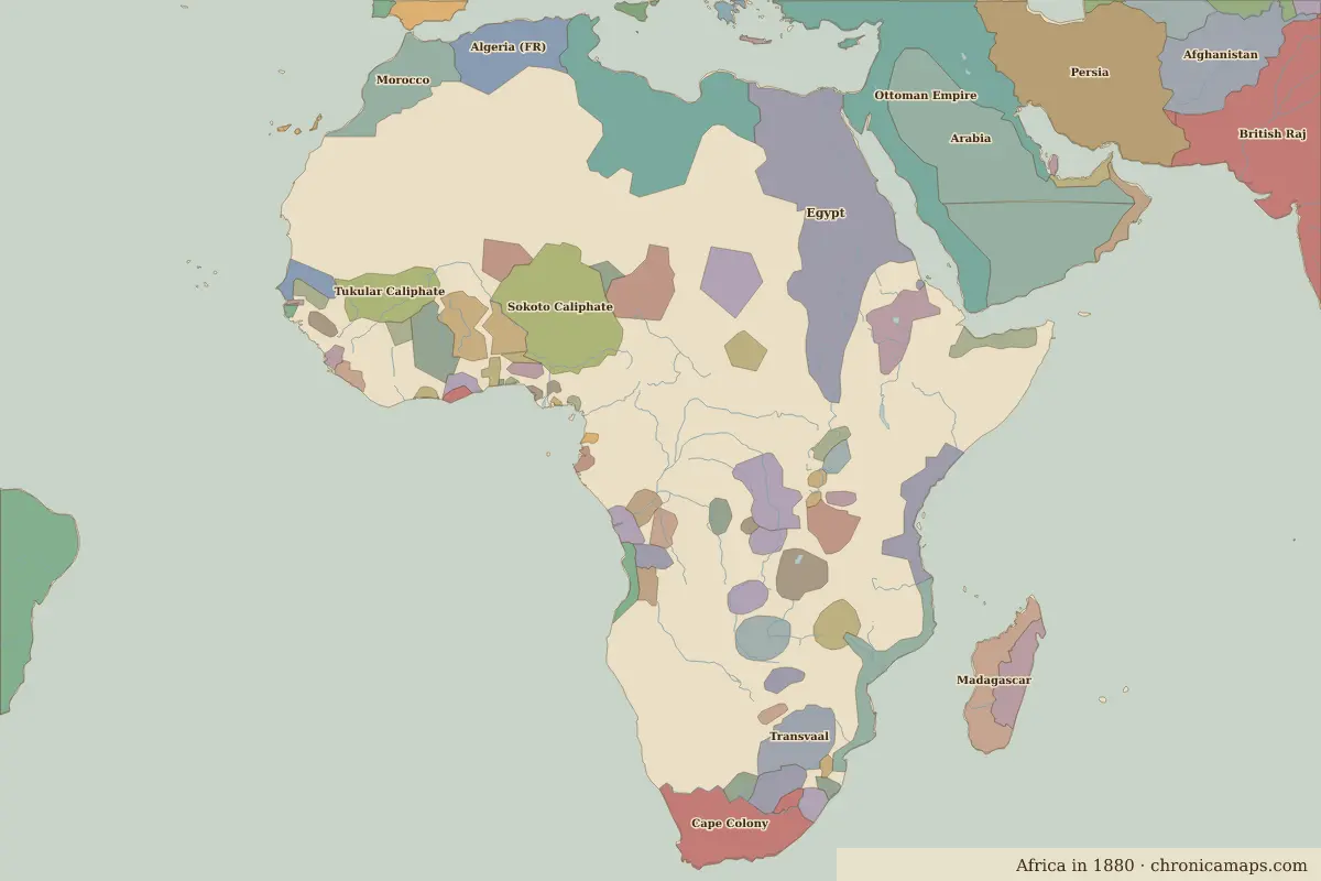
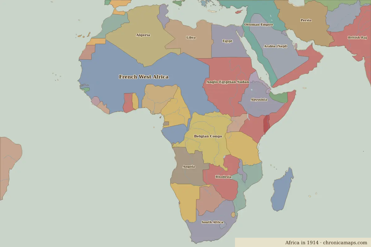
European powers divide almost the whole of Africa among themselves. Between 1880 and 1914, 31 states appear on the map of Africa and 53 disappear. Among those that vanish: Arabia, Sokoto Caliphate, Cape Colony. New on the map: French West Africa, Anglo-Egyptian Sudan, Algeria. Egypt loses the most territory.
Open 1914 in the interactive map
States that disappeared
| State | Area in 1880 |
|---|---|
| Arabia | 2.22 million km² |
| Sokoto Caliphate | 1.01 million km² |
| Cape Colony | 560,000 km² |
| Tukular Caliphate | 370,000 km² |
| Madagascar | 350,000 km² |
| Kanem-Bornu | 310,000 km² |
| Transvaal | 310,000 km² |
| Sultanate of Utetera | 300,000 km² |
| Sultanate of Zanzibar | 300,000 km² |
| Ethiopia | 280,000 km² |
| Wadai Empire | 260,000 km² |
| Kong Empire | 240,000 km² |
New states on the map
| State | Area in 1914 |
|---|---|
| French West Africa | 6.39 million km² |
| Anglo-Egyptian Sudan | 2.59 million km² |
| Algeria | 2.46 million km² |
| Belgian Congo | 2.35 million km² |
| Arabia (Nejd) | 1.77 million km² |
| Libya | 1.38 million km² |
| Angola | 1.24 million km² |
| South Africa | 1.23 million km² |
| Rhodesia | 1.15 million km² |
| Abyssinia | 1.14 million km² |
| German E. Africa (Tanganyika) | 1.00 million km² |
| Nigeria | 850,000 km² |
States that grew or shrank
| State | Change in area |
|---|---|
| Egypt | −1.03 million km² |
| Mozambique | +460,000 km² |
| Liberia | +50,000 km² |
| Sierra Leone | +40,000 km² |
| Portuguese Guinea | +20,000 km² |
What happened in between
| Year | Event | Where |
|---|---|---|
| 1896 | Battle of Adwa | Battle of Adwa |
| 1898 | Battle of Omdurman | Battle of Omdurman |
Battles of the period
- Battle of Adwa · 1896
- Battle of Omdurman · 1898
People of the period
| Lived | Person | |
|---|---|---|
| 1844 – 1913 | Menelik II | Emperor of Ethiopia |
| 1892 – 1975 | Haile Selassie I | Emperor of Ethiopia |
| c. 1897 – 1978 | Jomo Kenyatta | First president of Kenya |
| 1909 – 1972 | Kwame Nkrumah | First leader of Ghana |
Questions
How did the map of Africa change between 1880 and 1914?
Between 1880 and 1914, 31 states appear on the map of Africa and 53 disappear. Among those that vanish: Arabia, Sokoto Caliphate, Cape Colony. New on the map: French West Africa, Anglo-Egyptian Sudan, Algeria. Egypt loses the most territory.
Which states disappeared from the map of Africa between 1880 and 1914?
Arabia, Sokoto Caliphate, Cape Colony, Tukular Caliphate, Madagascar, Kanem-Bornu, Transvaal, Sultanate of Utetera, Sultanate of Zanzibar, Ethiopia.
Which new states appeared between 1880 and 1914?
French West Africa, Anglo-Egyptian Sudan, Algeria, Belgian Congo, Arabia (Nejd), Libya, Angola, South Africa, Rhodesia, Abyssinia.
Borders are drawn from the nearest available maps and are approximate.
Last updated 10 November 2026. Sources: border data from historical-basemaps, land and rivers from Natural Earth; texts written for Chronica Maps from standard reference works. How we make the maps.