Map of Europe in 1938
This border map shows Europe and the Mediterranean in 1938 (era: The World Wars). The largest states within the map area were USSR, Algeria (France) and Iran. The map stays in use until the next border change recorded in 1945.
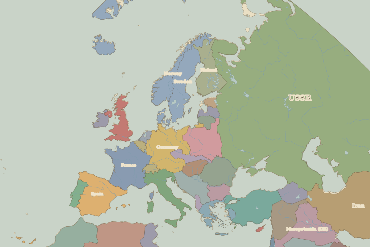
Open Europe in 1938 in the interactive map
States on the map in 1938
Areas are approximate and count only territory inside the map area.
| State | Approx. area on map |
|---|---|
| USSR | 8.80 million km² |
| Algeria (France) | 2.12 million km² |
| Iran | 1.58 million km² |
| Libya | 1.52 million km² |
| Saudi Arabia | 1.19 million km² |
| Egypt | 980,000 km² |
| Emirate of Bin Shal'an | 570,000 km² |
| Germany | 560,000 km² |
| Denmark | 560,000 km² |
| France | 550,000 km² |
| Mesopotamia (GB) | 550,000 km² |
| Spain | 500,000 km² |
| Turkey | 500,000 km² |
| French West Africa | 460,000 km² |
| Sweden | 440,000 km² |
| Morocco (France) | 410,000 km² |
| Poland | 390,000 km² |
| Finland | 370,000 km² |
| Norway | 350,000 km² |
| Syria (France) | 320,000 km² |
| Italy | 310,000 km² |
| Romania | 300,000 km² |
| Yugoslavia | 240,000 km² |
| United Kingdom | 230,000 km² |
| Hejaz | 200,000 km² |
Rulers in 1938
| Realm | Ruler | Reign |
|---|---|---|
| Franks / HRE / Germany | Hitler | 1933–1945 |
| France | Third Republic | 1870–1940 |
| England / UK | Edward VIII / George VI | 1936–1952 |
| Rus' / Russia | Stalin | 1924–1953 |
| Ottomans / Turkey | Atatürk | 1923–1938 |
Key events, 1938 to 1944
| Year | Event | Where |
|---|---|---|
| 1938 | Anschluss; Munich Agreement | |
| 1939 | Germany invades Poland; WWII begins | Warsaw |
| 1942 | Battle of Stalingrad | Battle of Stalingrad |
| 1943 | Battle of Kursk | Battle of Kursk |
| 1944 | D-Day landings in Normandy | Normandy Landings |
| 1944 | Republic of Iceland founded | Reykjavík |
Battles and sites in this period
- Battle of Stalingrad · 1942
- Battle of Kursk · 1943
- Normandy Landings · 1944
← Europe in 1930Europe in 1945 →
Part of the era: The World Wars.