The Carolingian Empire: Europe in AD 700 and AD 800
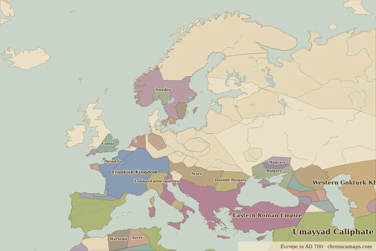
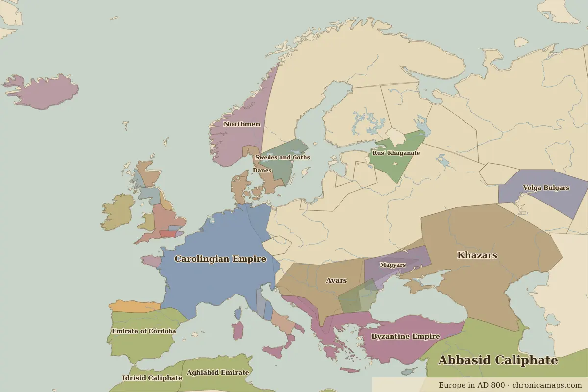
Between AD 700 and AD 800, 19 states appear on the map of Europe and 22 disappear. Among those that vanish: Umayyad Caliphate, Eastern Roman Empire, Frankish Kingdom. New on the map: Abbasid Caliphate, Carolingian Empire, Byzantine Empire. Khazars gains the most territory.
Open AD 800 in the interactive map
States that disappeared
| State | Area in AD 700 |
|---|---|
| Umayyad Caliphate | 4.46 million km² |
| Eastern Roman Empire | 1.36 million km² |
| Frankish Kingdom | 610,000 km² |
| Swedes | 290,000 km² |
| Warsenis | 170,000 km² |
| Danube Bulgars | 160,000 km² |
| Lombard principalities | 140,000 km² |
| Aures | 130,000 km² |
| Barghawata | 110,000 km² |
| Neustria | 100,000 km² |
| Caucasian Albania | 70,000 km² |
| Alans | 70,000 km² |
New states on the map
| State | Area in AD 800 |
|---|---|
| Abbasid Caliphate | 8.40 million km² |
| Carolingian Empire | 1.19 million km² |
| Byzantine Empire | 830,000 km² |
| Aghlabid Emirate | 620,000 km² |
| Idrisid Caliphate | 580,000 km² |
| Emirate of Córdoba | 490,000 km² |
| Northmen | 320,000 km² |
| Volga Bulgars | 260,000 km² |
| Rus' Khaganate | 120,000 km² |
| Swedes and Goths | 100,000 km² |
| Irish kingdoms | 80,000 km² |
| Mercia | 80,000 km² |
States that grew or shrank
| State | Change in area |
|---|---|
| Khazars | +1.36 million km² |
| Avars | +370,000 km² |
| Magyars | +120,000 km² |
| Danes | +90,000 km² |
| Bulgars | −70,000 km² |
What happened in between
| Year | Event | Where |
|---|---|---|
| AD 711 | Umayyad forces cross the Strait of Gibraltar | |
| AD 732 | Battle of Tours–Poitiers | Battle of Tours–Poitiers |
| AD 762 | The Abbasids found Baghdad | Baghdad |
| AD 793 | Vikings raid Lindisfarne | Lindisfarne |
| AD 800 | Charlemagne crowned emperor | Rome |
Battles of the period
- Battle of Tours–Poitiers · AD 732
- Lindisfarne · AD 793
People of the period
| Lived | Person | |
|---|---|---|
| c. AD 742 – AD 814 | Charlemagne | King of the Franks and emperor |
| c. AD 763 – AD 809 | Harun al-Rashid | Abbasid caliph |
| c. AD 780 – AD 850 | al-Khwarizmi | Mathematician |
Questions
How did the map of Europe change between AD 700 and AD 800?
Between AD 700 and AD 800, 19 states appear on the map of Europe and 22 disappear. Among those that vanish: Umayyad Caliphate, Eastern Roman Empire, Frankish Kingdom. New on the map: Abbasid Caliphate, Carolingian Empire, Byzantine Empire. Khazars gains the most territory.
Which states disappeared from the map of Europe between AD 700 and AD 800?
Umayyad Caliphate, Eastern Roman Empire, Frankish Kingdom, Swedes, Warsenis, Danube Bulgars, Lombard principalities, Aures, Barghawata, Neustria.
Which new states appeared between AD 700 and AD 800?
Abbasid Caliphate, Carolingian Empire, Byzantine Empire, Aghlabid Emirate, Idrisid Caliphate, Emirate of Córdoba, Northmen, Volga Bulgars, Rus' Khaganate, Swedes and Goths.
Borders are drawn from the nearest available maps and are approximate.
Last updated 10 November 2026. Sources: border data from historical-basemaps, land and rivers from Natural Earth; texts written for Chronica Maps from standard reference works. How we make the maps.