The Largest States in the World in 1500
On the world border map for 1500, the largest state was Chagatai Khanate, with about 8.37 million km² — some 6% of the world's land. It was followed by Ming Chinese Empire and Kalmar Union.
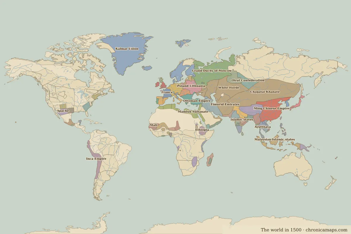
The 20 largest states in 1500
| Rank | State | Area | Share of world land | Rank in 1492 |
|---|---|---|---|---|
| 1 | Chagatai Khanate | 8.37 million km² | 5.6% | 1 |
| 2 | Ming Chinese Empire | 4.21 million km² | 2.8% | new |
| 3 | Kalmar Union | 3.07 million km² | 2.1% | new |
| 4 | Grand Duchy of Moscow | 2.77 million km² | 1.9% | 7 |
| 5 | White Horde | 2.63 million km² | 1.8% | 3 |
| 6 | Timurid Emirates | 2.16 million km² | 1.5% | 5 |
| 7 | Tibet | 1.98 million km² | 1.3% | 8 |
| 8 | Emirate of the White Sheep Turks | 1.82 million km² | 1.2% | 9 |
| 9 | Malaysian Islamic states | 1.75 million km² | 1.2% | 10 |
| 10 | Inca Empire | 1.55 million km² | 1.0% | – |
| 11 | Mamluk Sultanate | 1.47 million km² | 1.0% | 12 |
| 12 | Golden Horde | 1.09 million km² | 0.7% | 13 |
| 13 | Ottoman Empire | 1.09 million km² | 0.7% | 16 |
| 14 | Poland-Lithuania | 1.02 million km² | 0.7% | 14 |
| 15 | Sultanate of Delhi | 860,000 km² | 0.6% | – |
| 16 | Holy Roman Empire | 850,000 km² | 0.6% | 20 |
| 17 | Islamic states | 820,000 km² | 0.5% | new |
| 18 | Oirat Confederation | 810,000 km² | 0.5% | – |
| 19 | Ayutthaya | 780,000 km² | 0.5% | – |
| 20 | Burmese kingdoms | 710,000 km² | 0.5% | – |
Areas are measured from the border polygons of the map and are approximate; claimed areas, tributaries and unorganised land are not included.
Largest states by region
Europe
| Rank | State | Area |
|---|---|---|
| 1 | Kalmar Union | 3.07 million km² |
| 2 | Grand Duchy of Moscow | 2.77 million km² |
| 3 | Emirate of the White Sheep Turks | 1.82 million km² |
| 4 | Golden Horde | 1.09 million km² |
| 5 | Ottoman Empire | 1.09 million km² |
Asia
| Rank | State | Area |
|---|---|---|
| 1 | Chagatai Khanate | 8.37 million km² |
| 2 | Ming Chinese Empire | 4.21 million km² |
| 3 | White Horde | 2.63 million km² |
| 4 | Timurid Emirates | 2.16 million km² |
| 5 | Tibet | 1.98 million km² |
Africa
| Rank | State | Area |
|---|---|---|
| 1 | Mamluk Sultanate | 1.47 million km² |
| 2 | Mali | 620,000 km² |
| 3 | Songhai | 610,000 km² |
| 4 | Ethiopia | 590,000 km² |
| 5 | Mwenemutapa | 490,000 km² |
Americas
| Rank | State | Area |
|---|---|---|
| 1 | Inca Empire | 1.55 million km² |
| 2 | Apache | 550,000 km² |
| 3 | Cherokee | 420,000 km² |
| 4 | Aztec Empire | 340,000 km² |
| 5 | Comanche | 340,000 km² |
Oceania
| Rank | State | Area |
|---|---|---|
| 1 | Papua New Guinea | 420,000 km² |
| 2 | Tuʻi Tonga Empire | 20,000 km² |
Questions
What was the largest country in the world in 1500?
Chagatai Khanate, with about 8.37 million km², on the border map for 1500.
What were the five largest states in 1500?
1. Chagatai Khanate (8.37 million km²); 2. Ming Chinese Empire (4.21 million km²); 3. Kalmar Union (3.07 million km²); 4. Grand Duchy of Moscow (2.77 million km²); 5. White Horde (2.63 million km²).
What was the largest state in Europe in 1500?
Kalmar Union, with about 3.07 million km².
What was the largest state in Asia in 1500?
Chagatai Khanate, with about 8.37 million km².
What was the largest state in Africa in 1500?
Mamluk Sultanate, with about 1.47 million km².
← Largest states in 1492 · Largest states in 1600 → · Largest empires in history · The world in 1500
Last updated 10 November 2026. Sources: border data from historical-basemaps, land and rivers from Natural Earth; texts written for Chronica Maps from standard reference works. How we make the maps.