The Qing conquest: Asia in 1600 and 1700
Between 1600 and 1700, 13 states appear on the map of Asia and 17 disappear. Among those that vanish: Ming Chinese Empire, Islamic and Hindu states, Malaysian Islamic states. New on the map: Manchu Empire, Dutch East Indies, Post-Ming Warlords. central Asian khanates loses the most territory.
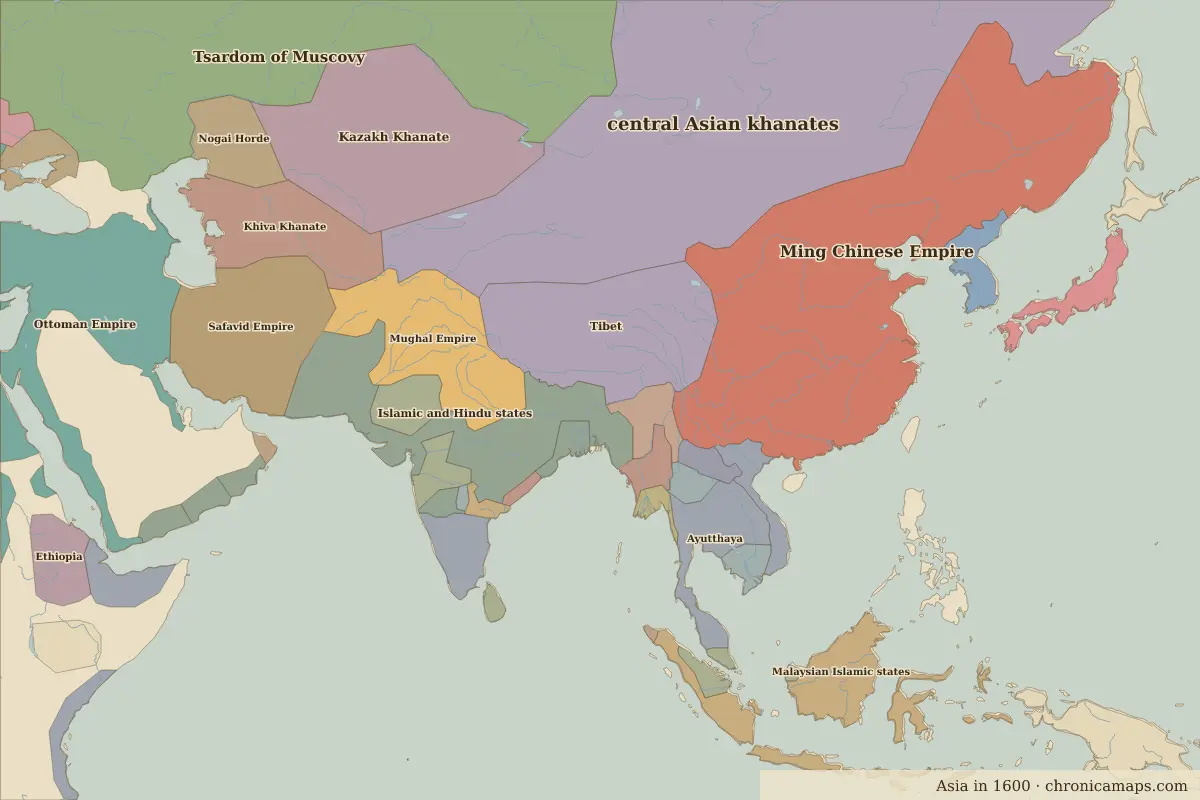
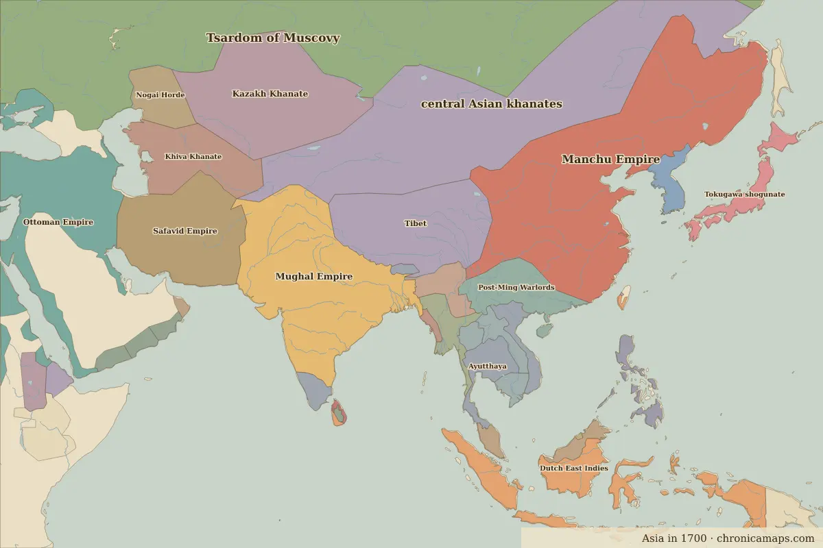
Open 1700 in the interactive map
States that disappeared
| State | Area in 1600 |
|---|---|
| Ming Chinese Empire | 6.03 million km² |
| Islamic and Hindu states | 1.99 million km² |
| Malaysian Islamic states | 1.37 million km² |
| Vijayanagara | 420,000 km² |
| Rajputana | 310,000 km² |
| Japan (Warring States) | 280,000 km² |
| Ahmadnagar | 230,000 km² |
| Burmese kingdoms | 200,000 km² |
| Malacca | 180,000 km² |
| Laos | 150,000 km² |
| Bengal | 140,000 km² |
| Pegu | 100,000 km² |
New states on the map
| State | Area in 1700 |
|---|---|
| Manchu Empire | 5.20 million km² |
| Dutch East Indies | 1.70 million km² |
| Post-Ming Warlords | 880,000 km² |
| Ava | 390,000 km² |
| Tokugawa shogunate | 360,000 km² |
| Malaya | 320,000 km² |
| Laotian states | 240,000 km² |
| Philippines | 230,000 km² |
| Hindu kingdoms | 180,000 km² |
| Arakan (Indian princely state) | 60,000 km² |
| Bhutan | 50,000 km² |
| Ceylon | 20,000 km² |
States that grew or shrank
| State | Change in area |
|---|---|
| central Asian khanates | −6.11 million km² |
| Mughal Empire | +2.45 million km² |
| Safavid Empire | +430,000 km² |
| Ayutthaya | −280,000 km² |
| Shan states | +70,000 km² |
| Lan Na | −20,000 km² |
What happened in between
| Year | Event | Where |
|---|---|---|
| 1644 | Fall of the Ming; the Qing enters China | Beijing |
| 1644 | Battle of Shanhai Pass | Battle of Shanhai Pass |
Battles of the period
- Battle of Shanhai Pass · 1644
People of the period
| Lived | Person | |
|---|---|---|
| 1542 – 1605 | Akbar | Mughal emperor |
| 1543 – 1616 | Tokugawa Ieyasu | First Tokugawa shogun |
| 1592 – 1666 | Shah Jahan | Mughal emperor |
| 1618 – 1707 | Aurangzeb | Mughal emperor |
| 1654 – 1722 | Kangxi Emperor | Qing emperor |
Questions
How did the map of Asia change between 1600 and 1700?
Between 1600 and 1700, 13 states appear on the map of Asia and 17 disappear. Among those that vanish: Ming Chinese Empire, Islamic and Hindu states, Malaysian Islamic states. New on the map: Manchu Empire, Dutch East Indies, Post-Ming Warlords. central Asian khanates loses the most territory.
Which states disappeared from the map of Asia between 1600 and 1700?
Ming Chinese Empire, Islamic and Hindu states, Malaysian Islamic states, Vijayanagara, Rajputana, Japan (Warring States), Ahmadnagar, Burmese kingdoms, Malacca, Laos.
Which new states appeared between 1600 and 1700?
Manchu Empire, Dutch East Indies, Post-Ming Warlords, Ava, Tokugawa shogunate, Malaya, Laotian states, Philippines, Hindu kingdoms, Arakan (Indian princely state).
Borders are drawn from the nearest available maps and are approximate.
Last updated 10 November 2026. Sources: border data from historical-basemaps, land and rivers from Natural Earth; texts written for Chronica Maps from standard reference works. How we make the maps.