Mongol conquests: Asia in 1200 and 1300
Genghis Khan and his successors build the largest contiguous land empire in history. Between 1200 and 1300, 14 states appear on the map of Asia and 23 disappear. Among those that vanish: Mongol Empire, Kara Khitai Khaganate, Song Empire. New on the map: Great Khanate, Chagatai Khanate, minor Hindu kingdoms. Sultanate of Delhi gains the most territory.
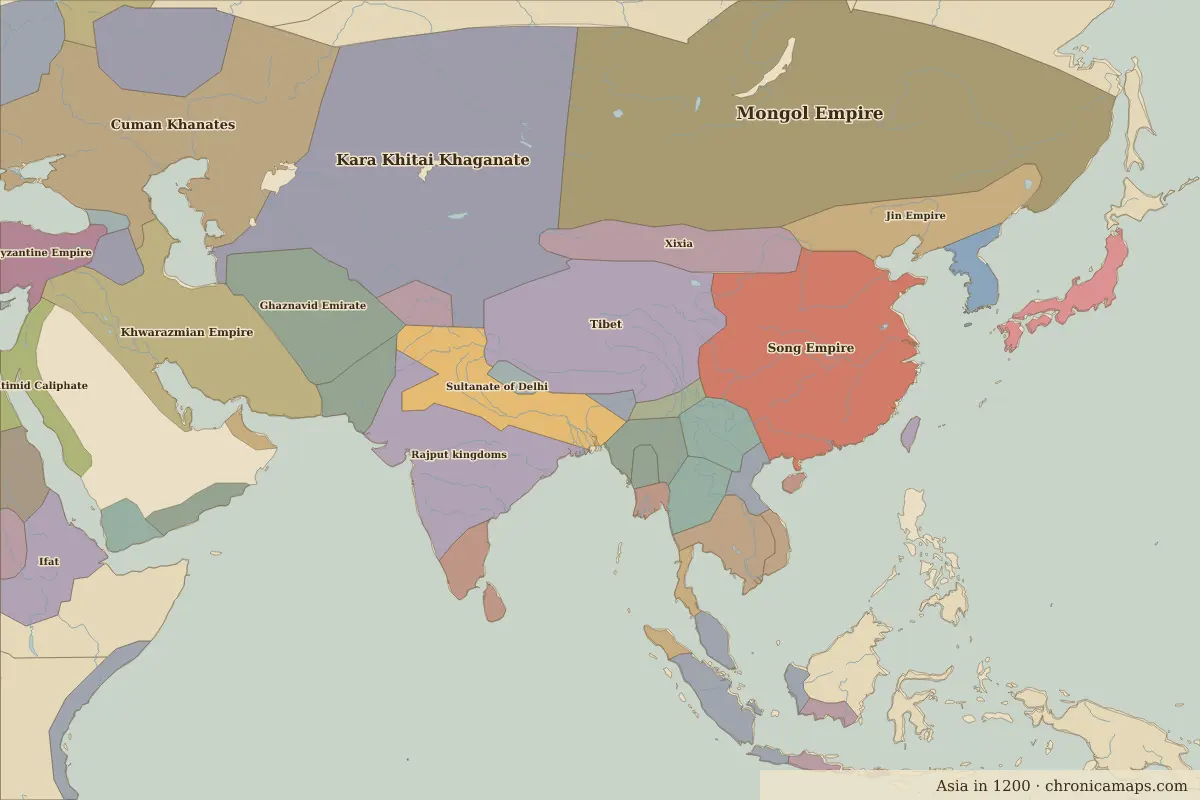
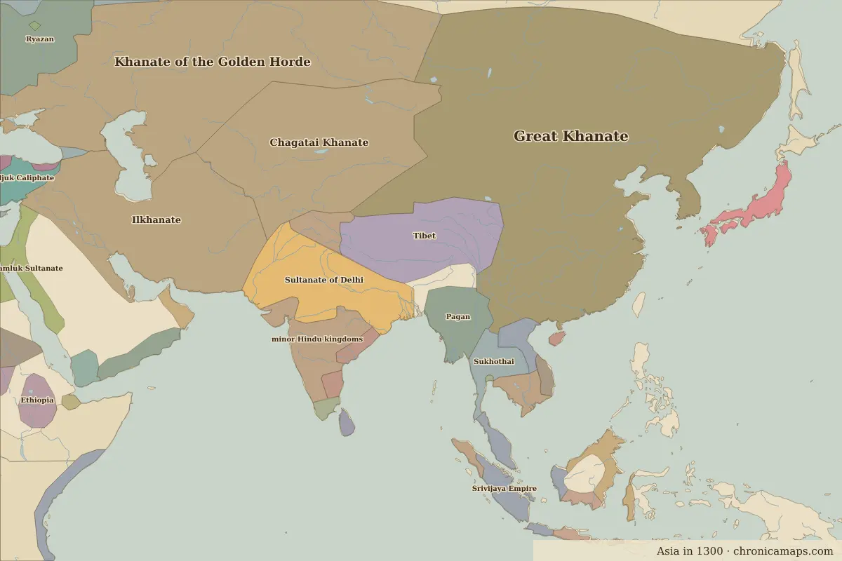
Open 1300 in the interactive map
States that disappeared
| State | Area in 1200 |
|---|---|
| Mongol Empire | 5.52 million km² |
| Kara Khitai Khaganate | 4.29 million km² |
| Song Empire | 3.00 million km² |
| Rajput kingdoms | 1.81 million km² |
| Ghaznavid Emirate | 1.16 million km² |
| Jin Empire | 790,000 km² |
| Xixia | 740,000 km² |
| Nan Chao | 410,000 km² |
| Khwarazmian dynasty | 370,000 km² |
| Harapunchai | 360,000 km² |
| Bagan | 340,000 km² |
| Imperial Japan (Fujiwara) | 280,000 km² |
New states on the map
| State | Area in 1300 |
|---|---|
| Great Khanate | 10.55 million km² |
| Chagatai Khanate | 3.31 million km² |
| minor Hindu kingdoms | 980,000 km² |
| Pagan | 730,000 km² |
| Sukhothai | 480,000 km² |
| minor Hindu and Buddhist kingdoms | 350,000 km² |
| Shogun Japan (Kamakura) | 280,000 km² |
| Kashmir and Ladakh | 270,000 km² |
| Kediri | 190,000 km² |
| Orissa | 140,000 km² |
| Champa | 100,000 km² |
| Aceh | 90,000 km² |
States that grew or shrank
| State | Change in area |
|---|---|
| Sultanate of Delhi | +820,000 km² |
| Tibet | −470,000 km² |
| Khmer Empire | −230,000 km² |
| Chola Empire | −220,000 km² |
| Đại Việt | +80,000 km² |
| Muscat | +40,000 km² |
What happened in between
| Year | Event | Where |
|---|---|---|
| 1206 | Temüjin becomes Genghis Khan | Karakorum |
| 1279 | Battle of Yamen: the end of the Southern Song | Battle of Yamen |
| 1281 | Second Mongol invasion of Japan fails | Battle of Mongol invasions of Japan |
Battles of the period
- Battle of Yamen · 1279
- Battle of Mongol invasions of Japan · 1281
People of the period
| Lived | Person | |
|---|---|---|
| c. 1122 – 1218 | Jayavarman VII | Khmer king |
| c. 1162 – 1227 | Genghis Khan | Founder of the Mongol Empire |
| 1207 – 1273 | Rumi | Poet and Sufi mystic |
| c. 1210 – 1291 | Saadi | Poet |
| 1215 – 1294 | Kublai Khan | Founder of the Yuan dynasty |
Questions
How did the map of Asia change between 1200 and 1300?
Between 1200 and 1300, 14 states appear on the map of Asia and 23 disappear. Among those that vanish: Mongol Empire, Kara Khitai Khaganate, Song Empire. New on the map: Great Khanate, Chagatai Khanate, minor Hindu kingdoms. Sultanate of Delhi gains the most territory.
Which states disappeared from the map of Asia between 1200 and 1300?
Mongol Empire, Kara Khitai Khaganate, Song Empire, Rajput kingdoms, Ghaznavid Emirate, Jin Empire, Xixia, Nan Chao, Khwarazmian dynasty, Harapunchai.
Which new states appeared between 1200 and 1300?
Great Khanate, Chagatai Khanate, minor Hindu kingdoms, Pagan, Sukhothai, minor Hindu and Buddhist kingdoms, Shogun Japan (Kamakura), Kashmir and Ladakh, Kediri, Orissa.
Borders are drawn from the nearest available maps and are approximate.
Last updated 10 November 2026. Sources: border data from historical-basemaps, land and rivers from Natural Earth; texts written for Chronica Maps from standard reference works. How we make the maps.