Map of Europe in 1650
This border map shows Europe and the Mediterranean in 1650 (era: Absolutism & Enlightenment). The largest states within the map area were Tsardom of Muscovy, Ottoman Empire and Safavid Empire. The map stays in use until the next border change recorded in 1700.
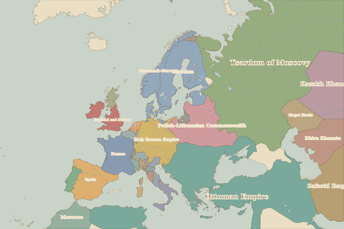
Open Europe in 1650 in the interactive map
States on the map in 1650
Areas are approximate and count only territory inside the map area.
| State | Approx. area on map |
|---|---|
| Tsardom of Muscovy | 4.97 million km² |
| Ottoman Empire | 4.82 million km² |
| Safavid Empire | 1.45 million km² |
| Kazakh Khanate | 1.40 million km² |
| Morocco | 980,000 km² |
| Sweden | 870,000 km² |
| Polish–Lithuanian Commonwealth | 840,000 km² |
| Khiva Khanate | 740,000 km² |
| Holy Roman Empire | 630,000 km² |
| Spain | 490,000 km² |
| France | 480,000 km² |
| Denmark-Norway | 390,000 km² |
| Nogai Horde | 370,000 km² |
| England and Ireland | 230,000 km² |
| Portugal | 90,000 km² |
| central Asian khanates | 90,000 km² |
| Naples | 70,000 km² |
| Scotland | 60,000 km² |
| Luxembourg | 60,000 km² |
| Papal States | 40,000 km² |
| Venice | 40,000 km² |
| Swiss Confederation | 40,000 km² |
| Prussia | 40,000 km² |
| Sardinia-Piedmont | 30,000 km² |
| Dutch Republic | 30,000 km² |
Rulers in 1650
| Realm | Ruler | Reign |
|---|---|---|
| Franks / HRE / Germany | Ferdinand III | 1637–1657 |
| France | Louis XIV | 1643–1715 |
| England / UK | Commonwealth and Lord Protector Cromwell | 1649–1660 |
| Spain | Philip IV | 1621–1665 |
| Rus' / Russia | Alexis | 1645–1676 |
| Ottomans / Turkey | Mehmed IV | 1648–1687 |
Key events, 1650 to 1699
| Year | Event | Where |
|---|---|---|
| 1683 | Second Siege of Vienna | Vienna |
← Europe in 1600Europe in 1700 →
Part of the era: Absolutism & Enlightenment.